
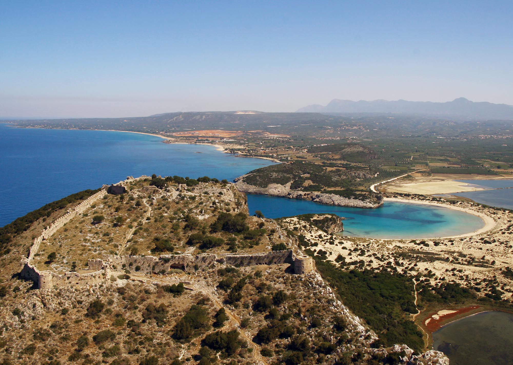
Palaiokastro
The castle commands the hill of the Koryfasio Peninsula, at the northern end of the Gulf of Navarino, northwest of Pylos. According to the Chronicle of the Morea, it was built between 1278 and 1289 by the Flemish crusader and prince of Achaia, Nicholas II of Saint-Omer. Its strategically chosen, naturally fortified location was of great political and military significance, as it was close to the borders of Venetian-held Methoni and overlooked the area’s natural harbour.
During medieval times, both the castle and the surrounding area were known as Port de Jonc (“Rush Harbour”) due to the rushes that grew on the coast. The castle was also referred to as Avarino, while in the late 16th century, after the Ottomans established the “new castle” (Pylos Niokastro), it was referred to as Paliokastro or Palaio (“Old”) Navarino.
ΑΠΟ ΤΟ ΠΑΡΕΛΘΟΝ ΣΤΟ ΠΑΡΟΝ
The Koryphasio Peninsula is rich in archaeological remains, testifying to human presence since the 3rd millennium BCE. In 425 BCE, the Athenians, at the urging of Demosthenes, fortified the most vulnerable parts of the hill, transforming it into a military base. The city that was subsequently established remained active during the Hellenistic and Roman periods.
Thus, the Frankish castle was built atop the foundations of the ancient fortifications. Its security quickly attracted people, leading to the formation of a small settlement outside its walls. In 1423, the castle was sold to the Venetians, who ruled it until 1500. During this period, specifically between 1440 and 1490 (according to the results of radiocarbon dating of the tower shutterings), a second, larger enclosure was constructed to the south, protecting the settlement that had already developed in this area.
In 1500, when Sultan Bayezid II captured Methoni and Koroni, the primary Venetian possessions in the Peloponnese, the castle surrendered to the Ottomans without resistance. In 1572, it came under siege by General Don Juan of Austria, but he failed to capture it. In response, the Ottomans constructed a new fortress, Niokastro, two years later to secure the southern mouth of the Gulf of Navarino. This development led to a decline in the strategic significance of Palaio Navarino, prompting the population to gradually move towards the new fortress. In 1686, the castle returned to Venetian control but was recaptured by the Ottomans in 1715, along with the rest of the Peloponnese.
In 1821, at the outset of the Greek Revolution, Greek forces conquered the castle and used it as a base for their military operations. However, in 1825, they surrendered it to Ibrahim Pasha. After the decisive naval Battle of Navarino in October 1827, the castle ultimately came under the control of the revolutionary Greeks.
THE CASTLE
The castle has a trapezoidal plan and consists of two enclosures separated by a transverse wall.
The upper enclosure, to the north, constitutes the original Frankish fortress. It was built atop the walls of the Hellenistic acropolis, remnants of which are still visible along the lower sections. The walls’ defences were reinforced with both square and semicircular towers.
Constructed by the Venetians between 1440 and 1490, the lower, southern enclosure was later repaired by the Ottomans after 1500. It spans three sides of the hill, while the eastern side, the steepest, remained unwalled. On the naturally fortified western side, the walls are vertical and topped with battlements. The more vulnerable southern side was reinforced and modified to accommodate firearms, with visible interventions from the late 15th–early 16th century as well as later periods.
THE GATES
The main gate of the castle is located on the southern side, at the base of a rectangular tower. It features pointed arches and was secured by a portcullis. Access was via a path leading from the southernmost point of the peninsula. The gate in the transverse wall separating the two enclosures is also preserved, although partially destroyed.
THE INTERIOR
Today, the remains of various buildings and facilities are preserved within the castle’s enclosures, which can be identified primarily through a 1706 map from the Grimani archive. These are the governor’s residence, houses, Catholic and Orthodox churches, and wells, while the main roads of the settlement are also shown. The large cisterns, where rainwater was stored to meet the inhabitants’ needs, especially during sieges, are among the best-preserved features.