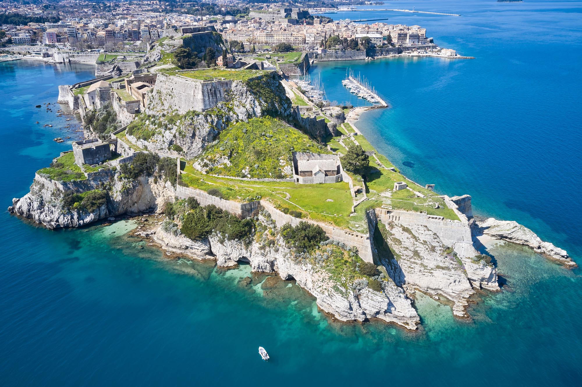
Old Fortress
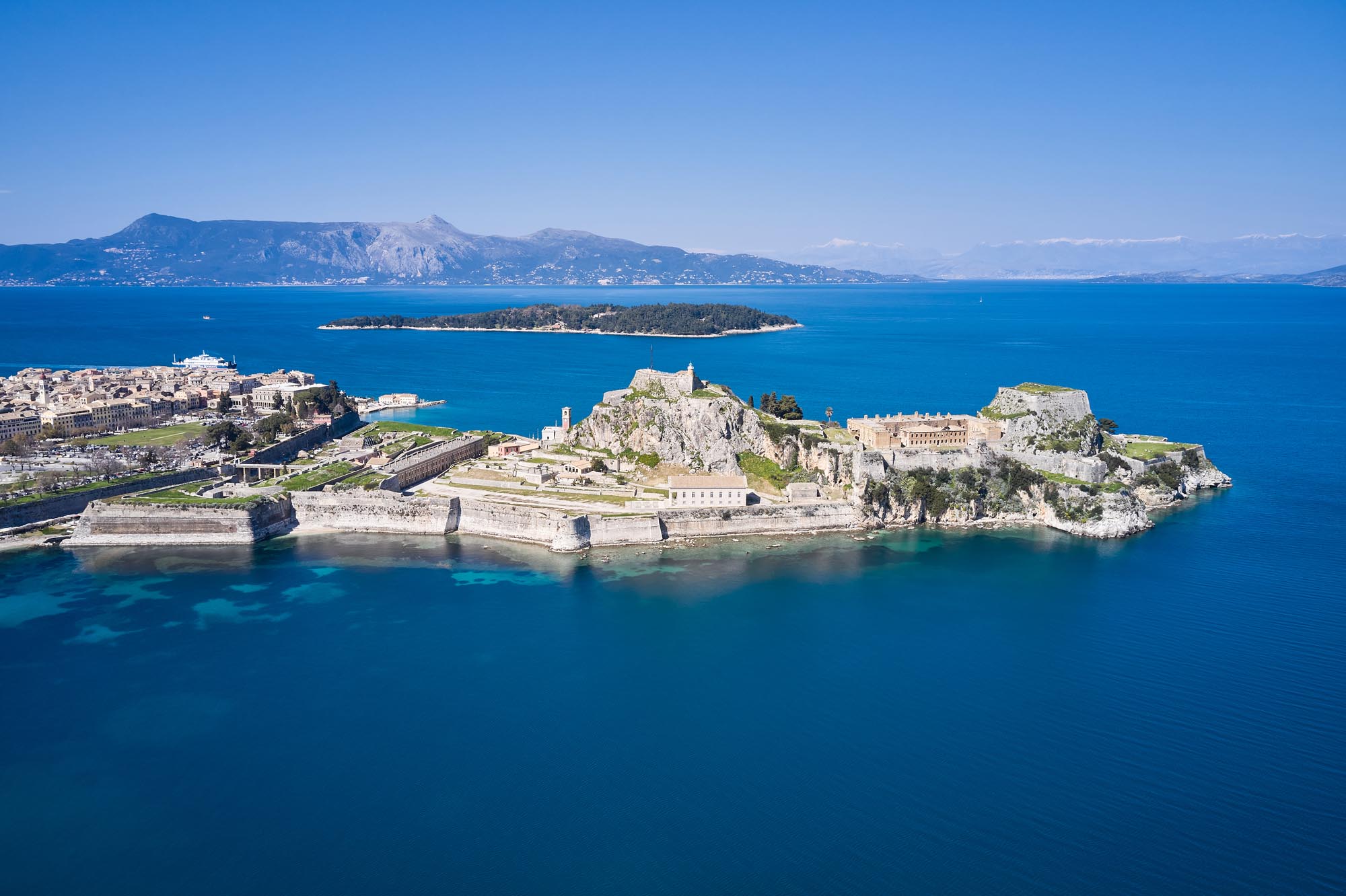
Corfu, situated in the northern Ionian Sea, occupies a strategically important location at the entrance to the Adriatic. It lies closer to Italy than any other region of Greece, while also being near both the Greek and Albanian coasts. Historically, the island has been characterised as “the key to the Adriatic”, “the sea gate” and “the mainstay of the Ionian islands”. The Old Fortress, the original heart of the medieval city, is located on the rocky peninsula east of the modern town of Corfu, occupying a naturally fortified position that offered control of sea routes. Together with the New Fortresses and the defensive fortifications around the Old Town, it formed a compact fortification system. This complex ensured Corfu remained the only Ionian island not to fall to the Ottomans, despite the repeated invasion attempts in 1430, 1537, 1571, 1573 and 1716. In recognition of its cultural and historical significance, Old Town of Corfu, the two fortresses and its perimeter fortifications, were inscribed on the UNESCO World Heritage List in 2007.
ΑΠΟ ΤΟ ΠΑΡΕΛΘΟΝ ΣΤΟ ΠΑΡΟΝ
The first fortifications on the peninsula date to the Byzantine era. During Venetian rule (1386–1797), when Corfu obtained particular commercial and military significance, the defences of the Old Fortress were reinforced, giving the structure its present-day form. Following the construction of the New Fortress in the 16th century and the fortification of the surrounding districts, the Old Fortress area was transformed into an exclusively military zone.
By the 10th century, Byzantine sources refer to Corfu as a “city”, distinguished by its large churches and ornate walls built from large, carved stones. In the 11th century, Byzantine princess Anna Komnene describes it as “a most fortified city”. According to a description by Byzantine scholar and high-ranking cleric Michael Choniates (12th c.), the eastern peak was initially fortified with a tower, later known as the Old Tower (Castel Vecchio), which was eventually renamed the Sea Tower.
Due to its geostrategic position, Corfu was periodically targeted by the Huns, Vandals, Goths, Arabs, Normans, Genoese pirates and Crusaders up to the fall of Constantinople to the Crusaders in 1204. However, despite these adverse conditions, the new settlement appears to have developed rapidly. Notably, by the 9th century, the Church of Corfu had been granted the status of an independent metropolis, directly subordinate to the Patriarch of Constantinople.
In 1204, Corfu came under the rule of the Republic of Venice and in 1207 it was granted as a fief to ten Venetian nobles. In 1214, it became part of the independent state (widely known today as the Despotate) of Epirus, where it remained until the mid-13th century, when Despot Michael II granted it as a dowry to his son-in-law, Manfred of Sicily. Corfu then came under Angevin rule in 1267, a period that lasted until 1386, when the island voluntarily returned to Venetian control. From that point, it remained the most important Venetian stronghold in the Adriatic and the Mediterranean for about four centuries.
The importance of the island increased further after the fall of Cyprus in 1571 and Crete in 1669 to the Ottomans. The Venetians came to regard it as the “gate to the gulf”, that is, the entrance to the Adriatic Sea. During this period, Corfu harbour evolved into one of the most important trading posts in the Mediterranean.
The period witnessed significant construction activity and population growth, alongside the economic boom on the island. The peninsula’s fortifications were reinforced and reconstructed to keep pace with developments in military technology. The western hill (Castel Nuovo) was also fortified, while the excavation of a moat on the western side transformed the peninsula into an island.
As early as the 10th century, the city of Corfu began expanding beyond the walls of the Old Fortress, giving rise to the suburbs (emporion, borgo). This extensive area remained unwalled until the Ottoman attack in 1571. In the aftermath of the siege and the near-total destruction of the suburbs, defensive walls were constructed around most of them. Between 1576 and 1588, the New Fortress was built on their western edge of the city to protect the growing urban area. After the walling of the newer settlement, the Old Fortress served exclusively as a fortress and administrative centre, with only a few residences remaining inside.
After the fall of the Venetian state, Corfu came under the control of the French Republic for two years (1797–1799). During this period, the French were not particularly concerned with fortification works. However, they improved the defences of the fortresses and proceeded to a rudimentary fortification of the island of Vido, installing a small number of cannons to protect the northern parts of the city and the harbour. These efforts were later completed under the French Empire from 1807 to 1814.
In 1799, allied Russian and Ottoman forces captured the island, and in 1800, the Septinsular Republic was established. In 1807, under the Treaty of Tilsit, Corfu, along with the other islands of the Ionian State, was ceded to the French Empire, under whose control it remained until 1814.
Under British rule (1815–1864), the fortifications were modernised, which included the demolition of several Venetian works. At the same time, parts of the perimeter wall were systematically removed to allow for urban expansion and city planning.
During World War II, bombings caused significant damage, mainly to the Venetian buildings within the Old Fortress. Most of these structures were demolished after the war.
THE FORTRESS
The Old Fortress occupies the entire peninsula area, which is 600 m long and 200 m wide. Its fortifications were constructed in successive phases, beginning in the Byzantine era. Under Venetian rule, they expanded outside the peninsula, where the city subsequently developed.
Today, three distinct phases of Venetian fortifications can be identified. The first period (1386–1537) radically changed the Byzantine fortification. A new and robust enceinte was erected in 1402, the citadel was reinforced and a sea moat (fossa) was opened, effectively separating the peninsula from the mainland. In addition, an artificial harbour was constructed at Mandraki, on the northern side of the peninsula. In 1501, the Land Tower was fortified, and in the 1510s the work intensified.
In the second period (1537–1571), the engineer Michele Sanmicheli designed and constructed the bastioned front on the western side of the fortress. Two pentagonal bastions, each topped with a cavalier, were erected at either end of the northwestern and southwestern parts of the peninsula. In most maps of the Venetian period, the northern bastion is named Savorgnan and the southern Martinengo, after the fortress commanders. A straight defensive wall (cortina) connected these two bastions. In the middle of this wall was a gate that was originally linked to the mainland by a movable wooden bridge. Under British rule, the bridge was placed on stone pillars, and today a 60-metre-long steel bridge stands in its place. Another part of the Venetian defensive works in the 16th century was the creation of an open firing range for the artillery at the Spianada, opposite the Martinengo and Savorgnan bastions, which involved the demolition of about 2,000 buildings.
Finally, during the third period (1571–1797), the suburb (borgo) was fortified (1571–1588), and the New Fortress (1571–1576) was built to bolster the city’s defences.
The fortification of the Old Fortress was developed on different levels. On the upper level, in the “citadel” (Cittadella), stands the so-called Old Tower, later renamed the Sea Tower, located at the eastern top, and the New Tower or Land Tower on the western side.
The middle level encompassed the broader western portion of the peninsula, with the bastioned front facing west, while the lower level included Cape Kavosidero and Mandraki.
THE GATES
The outer entrance gate to the fortress is located on the western side. It comprises eight stone pillars and dates to the Venetian period (1386–1797), with subsequent interventions made during British rule (1814–1864). The main gate is positioned between the Savorgnan and Martinengo bastions, facing the bridge. The entrance complex has a central vaulted passageway flanked by vaulted halls on either side. On the exterior, the arched opening is surrounded by a monumental architectural composition, while above the gate an escutcheon was installed after the union of the Ionian Islands with Greece. Prior to 1797, this spot bore the symbol of the Venetian Republic, the winged Lion of Saint Mark. The old wooden nailed door of the gate is still preserved, as are the slits in its stone frame through which the suspension chains of the movable bridge passed.
The fortress citadel was accessed through two gates, located to the south and west. The initial construction of the southern gate, dating to the Venetian period (1386–1797), consists of two rectangular rooms. The northern one served as a corridor, and the southern one as a garrison outpost. The gate possibly also had a movable section.
The western gate is situated at the base of the so-called Kabana (“Bell”) stronghold. It consists of two sections: an advanced outer gate with a wooden movable bridge and the main gate. From there, a vaulted corridor led inside the citadel, near the prison building.
Adjacent to the Mandraki tower, on the northern side of the peninsula, is the Sea Gate. It dates to the Venetian period (1386–1797), with later reconstructions and additions carried out under British rule (1814–1864). Facing the Mandraki harbour is the original main gate of the fortress, Soranza Gate. Constructed during the first phase of Venetian fortifications (1386–1573), it features a protruding frame with Renaissance decorative elements. When this entrance ceased to be used, the gate was sealed and later converted into a chapel dedicated to Saint Nicholas.
THE INTERIOR
The central entrance is flanked to the north and south by the Savorgnan and Martinengo bastions, each consisting of three levels and interconnected by staircases and vaulted corridors. Behind the bastions lay a second dry moat, which was bridged in 1603 with a stone structure, on which stood a Catholic chapel dedicated to Our Lady of Mount Carmel, built by Carmelite monks between 1636 and 1671. According to a French consul in the Ionian Islands, Jacques Grasset de Saint-Sauveur, prisoners condemned to death were transported there in chains 24 hours before their execution. At the end of the dry moat bridge are infantry barracks constructed during British rule (1814–1864), replacing a two-storey Venetian building arsenal. Today, these barracks house the General State Archives of Corfu and the Central Public Historical Library of Corfu.
Southeast of the barracks, at a higher elevation, stood the palace of the Venetian proveditore, which was destroyed during the bombings of World War II. North of the palace stands the Clock Tower, which is still preserved.
The southern side of the fortress – known as the Versiada – is dominated by the impressive church of Saint George, built in 1849, to meet the needs of the British garrison. This neoclassical monument was designed in the form of an ancient Greek Doric temple. Southwest of the church stands the Versiada Tower, built during the Venetian period (1386–1797), probably in the 15th century, and further west were the kitchens, in a building dating to the British period (1814–1864). To the east lies a gunpowder storeroom, on the eastern side is embedded the coat of arms of Marco Antonio Diedo, general proveditore of the sea, dated 1731. On the western side, the coat of arms of the Correr family is displayed, bearing the date 1727.
On the northern side of the fortress stood the palace of the general proveditore of the sea, the highest-ranking official in the Venetian naval hierarchy. According to archival sources, the building was constructed in the 16th century and was last used and repaired in 1794 by the last general proveditore, Carlo Aurelio Widmann. Below this palace lies Mandraki harbour, which served as the reception area for the Venetian official, who accessed his residence through the harbour gate. To the east of the general proveditore’s palace stood Pasqualigo barracks, built by General Proveditore Zorzi Pasqualigo in 1718–1721, with the capacity to accommodate 1,200 troops. To the east is the pharmacy building, constructed by the British in 1862–1864 on the site of an earlier Venetian-period building. South of Pasqualigo barracks was a food storage complex, built in the 16th century.
The citadel of the Old Fortress is dominated by the Old Tower (Sea Tower) on the east peak and the New Tower (Land Tower) on the west. The former, built on the bedrock, was accessed via a staircase from the southwest. Its initial fortification dates to the Byzantine period (10th c.) and it underwent repairs in the 1510s. The latter was fortified in 1501 by the Venetian engineer Giacomo Coltrini and later rebuilt by the British in the 19th century. Between the two towers lies a complex of buildings constructed under British rule that served as a hospital. Further south, atop the Land Tower, stands the lighthouse with an annexe, one of the first projects completed by the British in the fortress. In the citadel area was also the metropolitan church of Agioi Petros and Pavlos. The church, which has not survived, probably existed as early as the 10th century but ceased to function in 1633.
During British rule (1815–1864), the defence of the citadel was reinforced with the construction of the Crescent Battery to the west. This closed battery has four vaulted halls with cannon embrasures on their facades. Located near the western gate of the citadel is the prison building, the ground floor of which was constructed at the end of the Venetian period, in the 18th century, and the upper floor under British rule.
In the second half of the 16th century, Cape Kavosidero, at the northeastern end of the peninsula, was also fortified, its defences reinforced by the bastion of the same name. The portico leading to the bastion, an underground hall and a Venetian gunpowder storeroom are preserved in this area.