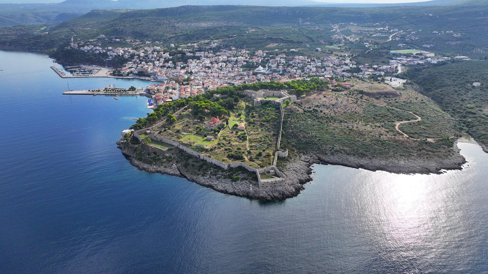
Niokastro
Built on a low hill at the southern entrance of Navarino Bay, Niokastro (or Neo Navarino) guarded access to one of the most important natural harbours in the eastern Mediterranean. Its location held particular strategic significance, serving as a key landmark on maritime routes between West and East. The name Neo (“New”) distinguishes it from the 13th-century Frankish castle, Palaiokastro (or Palaio Navarino), situated at the bay’s northern entrance.
ΑΠΟ ΤΟ ΠΑΡΕΛΘΟΝ ΣΤΟ ΠΑΡΟΝ
Niokastro was constructed by the Ottomans in 1573, immediately following their defeat at the naval Battle of Nafpaktos (1571), to secure their dominance over Navarino harbour. Muslims inhabited the walled settlement, while Greeks lived in two small settlements outside the walls. In 1686, the fortress was besieged and captured by the Venetians under Francesco Morosini. During Venetian rule (1686–1715), the castle was the capital of the district (territorio) of Messenia. In 1715, like the rest of the Peloponnese, it returned to Ottoman control. During the Orlov Revolt in 1770, it was briefly occupied by the Russian expeditionary force led by Alexei Orlov, who blew up the castle’s gunpowder storerooms and fortifications upon his withdrawal.
Immediately after the beginning of the Greek Revolution, the castle was besieged by Greek forces and finally surrendered to them in August 1821. Four years later, despite the heroic resistance of its defenders, it was recaptured by Ibrahim Pasha. In 1827, the fleets of the Great Powers – Britain, France and Russia – crushed Ibrahim’s Ottoman-Egyptian fleet in the Bay of Navarino. The following year, the French expeditionary force under General Maison captured the castle with little resistance. The French repaired the fortifications and constructed a barracks building, now known as the Maison building.
The Muslim settlement within the castle, which had been almost destroyed, was not inhabited again after 1828. The French expeditionary force designed modern Pylos, the new city that developed entirely outside the walls. During the 19th century, Niokastro served exclusively military purposes. From the second half of the century to the mid-20th century, the citadel housed the penal and then the political prisons of Pylos. In World War II, occupying forces used the castle as a base.
Extensive repairs and restorations were undertaken in the 1980s by the Ephorate of Underwater Antiquities, in the context of establishing the Centre of Underwater Archaeology. Since then, conservation and restoration works have continued steadily under the supervision of the Ephorate of Antiquities of Messenia.
THE CASTLE
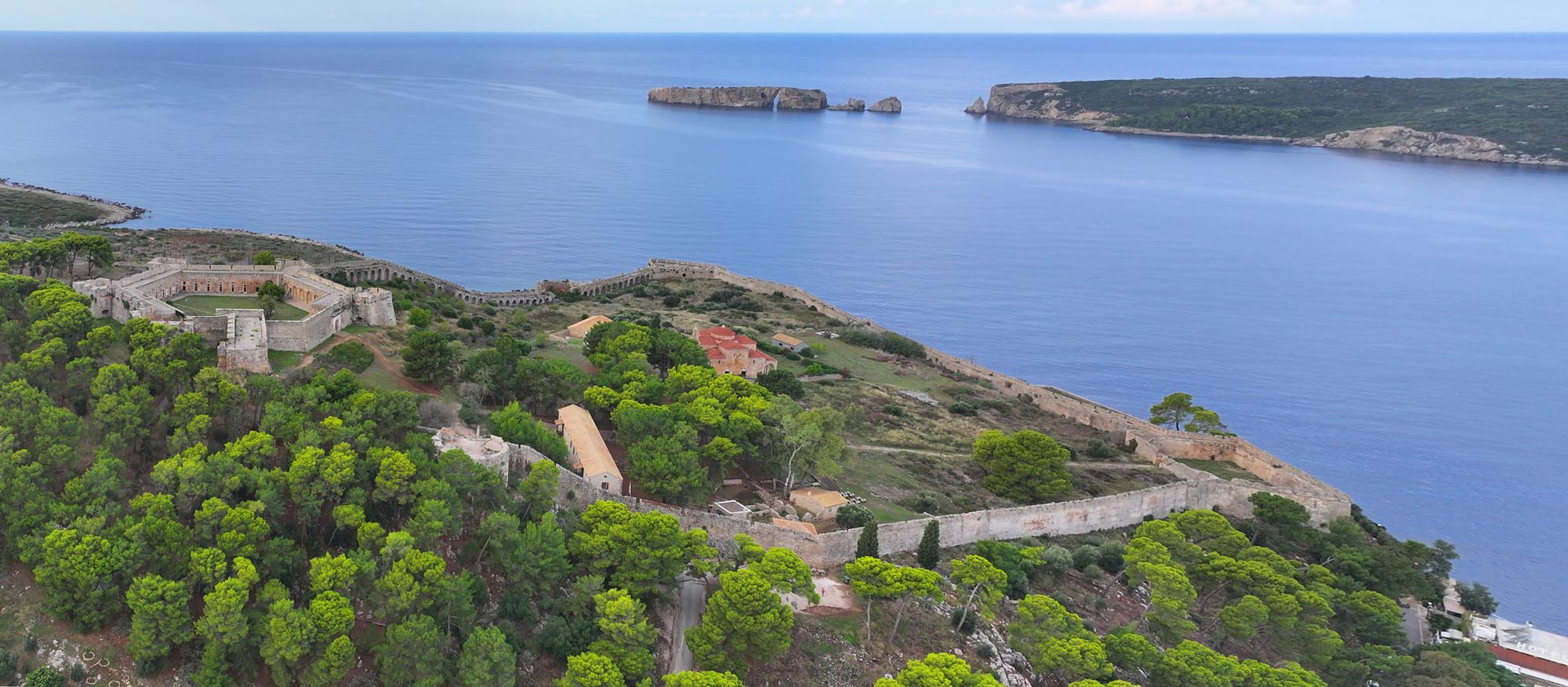
Niokastro was a walled coastal city with a hexagonal, star-shaped citadel covering approximately 7 hectares. The defensive walls enclosing the settlement were relatively thin and weak, with a narrow rampart-walk and battlements featuring cannon embrasures and gun slits. Circular artillery towers-bastions were positioned at midpoint of the long southern and northern sides of the wall – now known as the Megali Verga (on the southern wall) and Makrigiannis (on the northern wall) bastions. The Verga bastion, used as ammunition depot by the Italians during World War II, suffered extensive damage from Allied bombardment.
Along the coastline, two small, four-sided strongholds – or bastions – at the southern and northern ends of the settlement’s western wall controlled access to the Bay of Navarino with their cannons. In the southwestern end stands the Seventh or, as the Venetians called it, Santa Barbara stronghold. The bastion in the northwestern corner, known to the Venetians as the San Marco stronghold, is now called the Gymnasium, due to its use in the 20th century by schools in the area. The Seventh was destroyed in 1825 following an explosion in its gunpowder storeroom. Its current form largely reflects the interventions of the engineers of General Maison’s French expeditionary force. The Gymnasium bastion was damaged during World War II.
The inner hexagonal enclosure, the citadel, is fortified by strong, compact and low walls that feature a batter on their outer side. During World War II, these walls were used as machine-gun posts. The citadel bastions are hexagonal with two firing lines, one on the ground floor and another on the roof. Of the six original bastions, five survive today. Inside the fortification, a series of arches supports a broad access corridor that allowed the movement of cannons and defenders between the walls and the bastions. In the 19th century, when the fortress functioned as a prison, these arches were enclosed to form cells, and the hexagonal interior was divided radially with walls into five sections in which the prisoners spent their yard time. The Venetians reinforced the citadel’s fortification with a dry moat on its southern and eastern sides.
THE GATES
The current entrance to the castle is located in the northeastern section of the wall and provided access to the harbour. It is made from carved limestone and is covered by a semicircular arch. On the exterior, traces of a decorative rectangular built doorframe are still visible.
The entrance to the citadel is located on the northern side of the hexagon. It is a monumental limestone structure with a rectangular exterior frame, probably dating to the Venetian period of the castle (1686–1715).
The original main gate of the castle is located in the northeastern corner of the wall and is known as the Zematistra, which is the Greek word for machicolation. It was situated on the ground floor of a portal with three consecutive gates known as the Great Dome. The metal-lined wooden door leaves of the first, outer gate are still preserved today. To the north of the portal stood a circular tower to protect the entrance.
THE INTERIOR
Today, the remains of residences and public buildings that once formed the settlement are still preserved within the castle. At its peak, as described by the 17th-century Ottoman traveller Evliya Çelebi, the expansive outer enclosure contained 600 large konaks, two major mosques, a tekke, a khan, a hammam and 85 shops. He also recorded the existence of 200 houses outside the walls, where the Greeks resided.
Built as a mosque in the late 16th century, almost concurrently with the castle, the church of the Transfiguration of the Saviour stands out following its restoration. Along its southern side passed one of the city’s central stone-paved roads. During Venetian rule, the mosque was converted into a Catholic church dedicated to Saint Vitus. In the early 19th century, the French expeditionary force probably used the building as a food storage facility. After 1842, it was converted to Orthodox worship and dedicated to the Transfiguration of the Saviour, remaining as Pylos’ main church until the 1980s. It consists of the nave, square in plan, and the porch. Inside, the ornate mihrab from its time as a mosque is preserved.
Near the current entrance of the castle stands the Maison building, as the barracks of the French expeditionary force is known. The ground floor houses Pylos Archaeological Museum and its permanent exhibition, which narrates the history of Pylia from prehistory to Roman times. Almost at the centre of the outer enclosure is the so-called Pasha Building, Ibrahim’s residence according to tradition, which today serves as an exhibition area for the Ephorate of Underwater Antiquities. Additional exhibitions related to underwater antiquities are displayed in the vaulted spaces of the citadel and the Makrygiannis bastion on the settlement’s northern wall.
THE NIOKASTRO AQUEDUCT
The Ottomans built an aqueduct with two branches to address the lack of water sources and to serve the needs of the garrison and the inhabitants of Niokastro. One branch was supplied by the Palio Nero spring, located 6 km from the castle, and the second by the Chandrinos Koubes spring, 12 km away. The aqueduct pipeline terminated in cisterns within the citadel and the settlement, from where water was channelled to above-ground fountains.