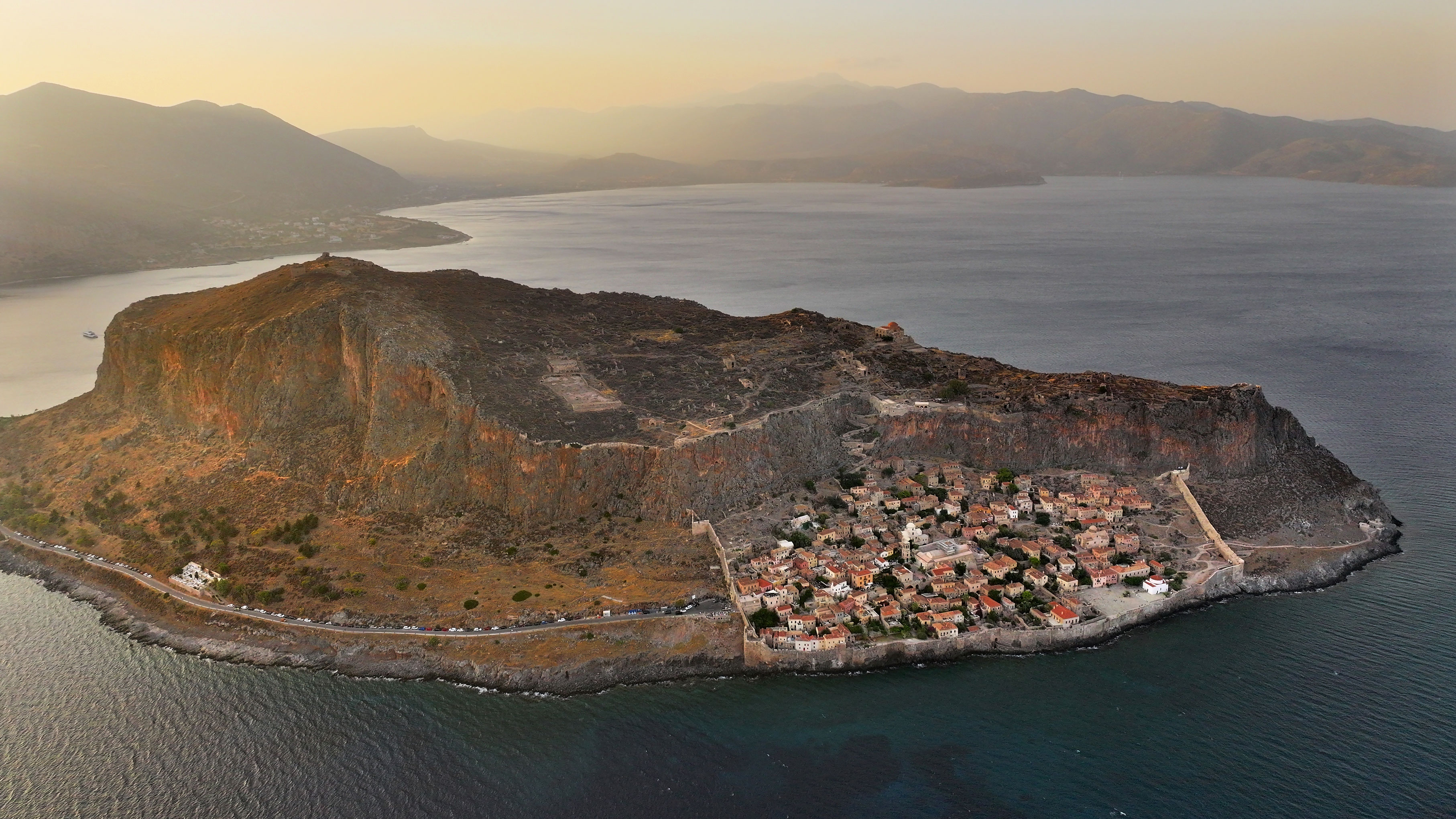
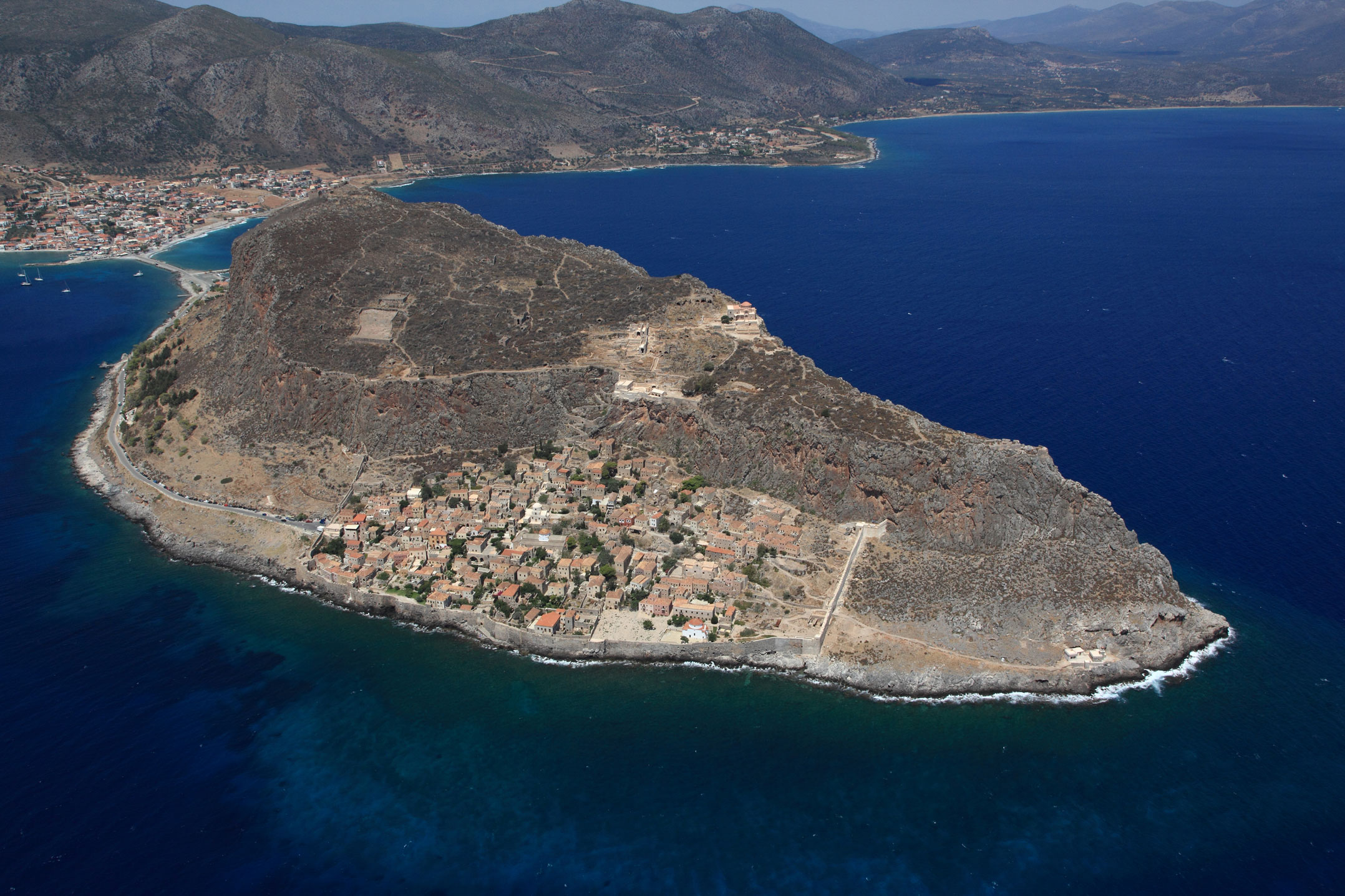
Monemvasia
Monemvasia Castle is located north of Cape Maleas, on the coast of the province of Epidaurus Limera, atop a rocky peninsula connected to the mainland by a narrow isthmus. The natural inaccessibility of the castle-city ensured its effective defence and allowed control over the maritime routes in the Myrtoan Sea, establishing it as a hub of communication between East and West.
The name Monemvasia derives from its sole connection to the mainland – την μόνην έμβασιν (“the only entrance”). The striking natural landscape, combined with the beauty of the castle-city, has inspired various names over time. Europeans referred to it as Malvasia, a Latin corruption of the Greek word Monemvasia. The 17th-century Ottoman traveller Evliya Çelebi called it Menekşe Kalesi (“Castle of Flowers”), after the abundance of blossoms covering the peninsula. In the 20th century, its unique setting continued to captivate writers: Nikos Kazantzakis described it as the “Gibraltar of Greece”, Yiannis Ritsos as a “Stone Ship” and Stratis Myrivilis as “the still-living Mistras”.
ΑΠΟ ΤΟ ΠΑΡΕΛΘΟΝ ΣΤΟ ΠΑΡΟΝ
The earliest settlement on the rock of Monemvasia dates to the 6th century. It concerns the small fortress on the highest plateau of the peninsula, which later became the citadel of the castle-city. Most scholars attribute its construction to Byzantine Emperor Justinian, as part of the effort to reinforce the fortifications of the empire.
During the turbulent period in the Peloponnese between the 6th and 8th centuries – marked by the decline of ancient cities, their transformation into medieval fortresses, and the raids and migration of Slavic tribes – the naturally fortified rock of Monemvasia served as a refuge for people, mainly from nearby areas. The initial settlement soon expanded into the Lower Town. In the centuries that followed, Monemvasia’s strategic position in the Mediterranean and its role as a transit hub for trade between Italian cities, the Black Sea and the eastern Mediterranean, made it a gateway between Western Europe and the Byzantine Empire. The harbour grew in importance, and its skilled seafaring inhabitants were granted privileges by the Byzantine emperors, including tax exemptions and partial self-government.
Owing to its strategic location, Monemvasia came under threat from both the Arabs and Normans, but its natural fortifications allowed it to repel them. In 1248, after a long siege and under the condition that it would retain its privileges, the castle-city surrendered to William II of Villehardouin, the Frankish ruler of the Principality of Achaia. A few years later, in 1262, Monemvasia, along with the castles of Mistras, Geraki and Megali Maini, was ceded to the Byzantines in exchange for the release of the captured William.
Over the next two centuries, Monemvasia’s privileges were renewed, supporting its agricultural, industrial and commercial development, while it served as a base of the Byzantine fleet.
In 1460, its inhabitants surrendered the city to Pope Pius II to avoid falling to the Ottomans. Just three years later, during the First Venetian-Turkish War (1463–1479), they surrendered it again, this time to the Venetians.
The Venetians ruled the city until 1540, when they ceded it to the Ottomans as compensation for losses suffered during the Third Venetian-Οttoman war (1537–1540). Under Ottoman administration, the population of Monemvasia shrank, and the Upper Town was gradually abandoned. In 1690, during the Sixth Venetian-Οttoman War (1684–1699), the Venetians recaptured the city after a long siege, ushering in a new period of growth. In 1715, during the Seventh Venetian-Οttoman War (1714–1718), the Ottomans retook Monemvasia, along with the rest of the Peloponnese. In 1770, the inhabitants joined the Orlov Revolt, but their uprising was quickly suppressed by the Ottomans.
During the Greek Revolution of 1821, Greek forces besieged Monemvasia for about four months before capturing it on 23 July. The castle remained in use throughout the revolution, especially during the civil wars. From 1830 onwards, it became part of the new Greek state.
Throughout the 19th century, Monemvasia remained a small settlement and never regained the prosperity it enjoyed in Byzantine times. In the early 20th century, most of its inhabitants relocated to the new settlement of Gefyra, situated at the entrance to the peninsula, leaving the historic city almost abandoned. In 1965, the entire peninsula was declared a historical monument, marking the beginning of the systematic conservation of its monuments and the restoration of its buildings.
THE CASTLE
The fortifications and urban planning of Monemvasia are adapted to the natural terrain. In line with the typical layout of Middle and Late Byzantine cities, Monemvasia is divided into three sections: the citadel (or castle), located at the western edge of the hill and serving as the military centre and last refuge for the population in times of siege; the Upper Town, spread out on the flat part of the hilltop and housing military facilities and aristocratic residences; and the Lower Town, built on the southeastern slope, where sailors and merchants lived. The Lower Town, which is still inhabited, also hosted the commercial shops of medieval Monemvasia.
LOWER TOWN - The fortifications
The Lower Town was enclosed by a Pi-shaped wall, with its northern side left unfortified due to the natural protection offered by the steep cliffs of the peninsula. The eastern and western sections of the wall follow the slope of the terrain, while the southern side follows the coastline. The wall has gun loops and positions for firearms along its entire length, while it was reinforced with small bastions, towers and outposts. The wall’s northeastern tower, which served as garrison quarters, along with the bastions on its western, southern and northeastern sides, are the best-preserved parts of the wall.
LOWER TOWN - The gates
The Lower Town had four main entry and exit points: the central gate on the western side, a sea gate – known as the “Portello” – on the southern wall, a gate on the eastern side and a northern gate through which the road to the Upper Town passed.
Today, the castle-city of Monemvasia is accessed through its only central gate on the western side, via a vaulted passage set in the middle of the defensive wall. The gate features elaborate marble revetment and was protected by a marble machicolation. From this point began the main thoroughfare of the Lower Town, known to the Byzantines as the Middle Street. During the second period of Venetian rule (1675–1715), it was referred to as the Agora or Foros (i.e., Forum). It now bears the name Yiannis Ritsos Street. This road was the commercial heart of Monemvasia, lined with shops and workshops operating on the ground floors of the houses. A second road axis ran through the Lower Town, beginning at the sea gate (Portello), passing through the central square of the church of Elkomenos Christos, continuing north through the houses and eventually connecting with the road to the Upper Town.
LOWER TOWN - The interior
One of the first buildings encountered upon entering the Lower Town, on the left of the Middle Street, is the house of the poet Yiannis Ritsos, which is currently being transformed into a museum. Further down, the Middle Street reaches the main square of the Lower Town, where two significant structures are located: the metropolitan church of Elkomenos Christos, built in the 6th–7th century and extensively renovated in the 11th century, as well as a 16th-century Ottoman mosque, which now houses the city’s archaeological collection. The Middle Street ends at the gate of the eastern wall, where a path leads to Monemvasia Lighthouse, built in the 19th century at a point with a striking view.
All the buildings in the Lower Town exhibit special architectural features, as the narrowness of the space and the defence needs led to them to being built close together and, in many places, connected by vaulted passages.
In the 18th and 19th centuries, the Ottomans modernised the city’s defences in the face of attacks with firearms by creating two open areas along the southern wall for the deployment of military units, breaking up its dense construction. These plateaus consist the small and the great bastions on the western and eastern sides of the city, respectively. On the flat area of the great bastion stands a 16th-century church dedicated to Panagia Chrysafitissa. In total, 26 churches are preserved in the Lower Town, including Panagia Myrtidiotissa (or Kritikia) and Agios Nikolaos of Likinios, both built during the second period of Venetian rule.
UPPER TOWN - The fortifications
The Upper Town is enclosed by a strong defensive wall with small towers, mainly on the southern side and on part of its northern side, with its oldest sections dating to the 6th century. The fortification is not continuous, as in some areas the natural bedrock provided sufficient protection. The northern side of the Upper Town wall is known as Mura Rossa, a name attributed to it by the Venetians due to the reddish mortar on its facade.
The Upper and Lower Towns were connected by a winding paved path, known as the Voltes (“strolls”). The path is flanked by high walls, some sections of which feature battlements to protect those passing through during a siege. The path leads to the only gate of the Upper Town, located on its southern side.
UPPER TOWN - The building complex of the Upper Town gate
The central gate to the Upper Town is located on the southern side of the walls and leads to the western side of a large building complex. Arranged over two levels, this complex played a key role in the defence of Monemvasia. It included individual rooms used by the garrison, and its current form reflects successive construction phases carried out by the various powers that ruled the city.
The gate still preserves its original wooden doors, elaborate stone decoration and arched lintel. The Upper Town was accessed through elongated vaulted passages, around which rooms of various uses were developed. In particular, a mihrab has been identified in one room that appears to have been used as a mosque during the first period of Ottoman rule (1675–1715), while another room was used as a prison. Two cisterns and a two-aisled church of the Late Byzantine period (13th–15th c.), the name of which has not yet been identified, are also preserved. During the second period of Ottoman rule (1715–1821), the church appears to have been abandoned, as a semicircular guardhouse was attached to its southern wall and a transverse wall was built to block off the sanctuary.
The upper floor of the gate complex, in its current form, includes a rectangular building composed of three vaulted rooms, whose roof formed a bastion with a cannon embrasures. This building was in use until 1831. Modern research has revealed the existence of other rooms on the upper floor, used for military and storage purposes, although they have not been preserved intact.
Another gate, on the northern side of the Upper Town walls, was sealed by the Ottomans in the 16th century with a defensive wall.
UPPER TOWN - The interior
Immediately beyond the gate, a wide open space accommodated cannons and the deployment of troops. A small unidentified Late Byzantine church (13th–15th c.) stands in this area.
West of this area stands a large two-storey building – the residence of the Venetian governor of Monemvasia from 1510 to 1512, Sebastiano Renier. His coat of arms is preserved on the marble rim of the building’s cistern. The most important monument of the Upper Town – and the only one that remains intact – is located on its northeastern side: the 12th-century church of Agia Sophia, or Panagia Odigitria. A Greek cross-domed octagon, (with a large dome resting on eight piers or pilasters), it is noted for its architecture and painted decoration. During the two periods of Venetian rule in Monemvasia (1463–1540 and 1690–1715), it functioned as a Catholic monastery dedicated to the Madonna del Castello and Madonna del Carmine, respectively. In the 16th century, during Ottoman rule, it was converted into a mosque.
Among the ruins of the Upper Town are two restored houses (houses 70 and 71), three large rainwater cisterns (Katergo/Galeazza, Karavi/Galera and Keratsini/Bastarda), an Ottoman mausoleum and a bath.
THE CITADEL
The citadel is located at the highest point of Monemvasia, just west of the Upper Town. It is considered the earliest fortification on the peninsula, constructed by inhabitants from Sparta in the 6th century. As the settlement expanded, the original fortress was transformed into a citadel. It has a trapezoidal plan and is reinforced with square towers at each corner. In the northeastern corner stands a massive circular tower that served as a watchtower, while in the southeastern corner, the Venetians built a large rectangular structure in the late 17th century that functioned as a gunpowder storeroom.