Methoni
The imposing coastal castle of Methoni fortified a narrow cape jutting into the sea at the southernmost end of the western Peloponnese. The small peninsula, together with the islands of Sapienza and Schiza, shelters the natural anchorage in the small bay east of the castle. Methoni’s renowned harbour was a strategically important stop on the maritime routes between West and East. It flourished as a Venetian possession between the 13th and 15th centuries and, together with neighbouring Koroni, was described as one of the “main eyes” of Venice (oculi capitales Communis Veneciarum) in the East.
The site of the castle has been inhabited since ancient times. During the Peloponnesian War, Methoni maintained a small garrison and had weak walls, according to Thucydides. In 31 BCE, during the war between Augustus, Mark Antony and Cleopatra, General Agrippa captured Methoni after a siege. After the 2nd century, Methoni obtained relative autonomy and minted its own coins, some of which depict its harbour. In 365, a strong earthquake, followed by a large tsunami, destroyed the settlement.
ΑΠΟ ΤΟ ΠΑΡΕΛΘΟΝ ΣΤΟ ΠΑΡΟΝ
During the Byzantine period, Methoni served as a commercial centre and a resupply station on the sea route from the West to the Eastern Mediterranean. However, it remained a secondary regional harbour and a base of operations for pirates, according to the few references in contemporary written sources. It was among the locations within the empire where the Venetians could trade freely without customs duty. Its geographical location and growing significance often attracted invaders, mainly from the Italian peninsula. Methoni was plundered and razed in 1125 and 1171 by the Venetians, in 1147 by Roger II, the Norman king of Sicily, and in 1199 by the Genoese pirate Leone Vetrano.
In 1206–1207, following the fall of Constantinople to the knights of the Fourth Crusade and the subsequent dismemberment of the Byzantine Empire, the Venetians captured Methoni with their fleet, destroying the castle and expelling the Franks, who had held it since 1205. In 1209, the Treaty of Sapienza between the Frankish Principality of Achaia and the Republic of Venice formally recognised Venice’s sovereignty over both Methoni and Koroni two castles in the southwestern Peloponnese, often collectively referred to as “Mothokorona”, sealing their shared historical course.
The three centuries of Venetian rule that followed marked a period of great prosperity for Methoni. The castle fortifications, which had been destroyed in raids over the previous two centuries, were repaired and remodelled by the Venetians. The harbour emerged as a primary station and a major geopolitical hub in Venice’s trade routes, the most significant maritime network before the discovery of the New World. It was a mandatory stop for products and people travelling between the Eastern Mediterranean and the Black Sea basin, Italy and northern Europe. Western pilgrims en route to the Holy Land, nobles and officials, and even the last Byzantine emperors, when they went to seek help in the West against the Ottoman threat in vain, stopped in Methoni to resupply and repair their ships.
In 1500, this crucial Venetian colony fell to the Ottomans after a long siege, which was followed by extensive looting and a massacre. Many inhabitants fled to the Ionian Islands, leaving the settlement deserted. The Ottomans relocated people from other areas of the Peloponnese to Methoni to repopulate it. As an Ottoman fortress and harbour, it lost the central role it had held in the Eastern Mediterranean as a Venetian colony, bringing its period of great prosperity to a definitive end.
In 1686, the Venetians recaptured Methoni and held it for 30 years until 1715, when the Ottomans regained control of it. During the second period of Ottoman rule, Methoni declined into a relatively insignificant city, though its castle remained garrisoned and retained its defensive capabilities. It withstood an attack by Russian Orlov troops in 1770 and later served as a refuge for the region’s Muslim population following the outbreak of the Greek Revolution of 1821. In 1825, Ibrahim Pasha, head of the Ottoman-Egyptian army sent to suppress the revolution, disembarked at Methoni and established his headquarters there.
Following the naval Battle of Navarino, the Ottomans surrendered the castle to General Maison, commander of the French expeditionary force in 1828. The French carried out works on the castle and planned a new settlement outside the walls, where the suburb (borgo) had already existed since the first period of Venetian rule. The castle settlement was dismantled and building materials from it were used in new constructions. The castle ceased to have military use in the mid-19th century and was likely abandoned, although it is known to have sheltered refugees after the Asia Minor Catastrophe in the 1920s. During World War II, it served as a base for the Italian and German occupation forces and was bombarded by the Allies, resulting in significant damage to its western walls.
THE CASTLE
The long history of the coastal city, marked by devastating raids, sieges and successive rulers, is inscribed on the very walls of Methoni Castle. In many sections, the symbol of Venice, the winged Lion of Saint Mark, along with the coats of arms of governors responsible for the repair or construction of the fortifications, remain visible.
The castle in its present form is largely the result of construction phases and modifications carried out between the 13th and early 18th centuries. Archaeological evidence confirms that ancient, Roman and Byzantine Methoni once occupied the site of the Venetian castle. The earlier fortifications survive only in fragments, having been incorporated mainly in the later modifications and reinforcements undertaken by the Venetians.
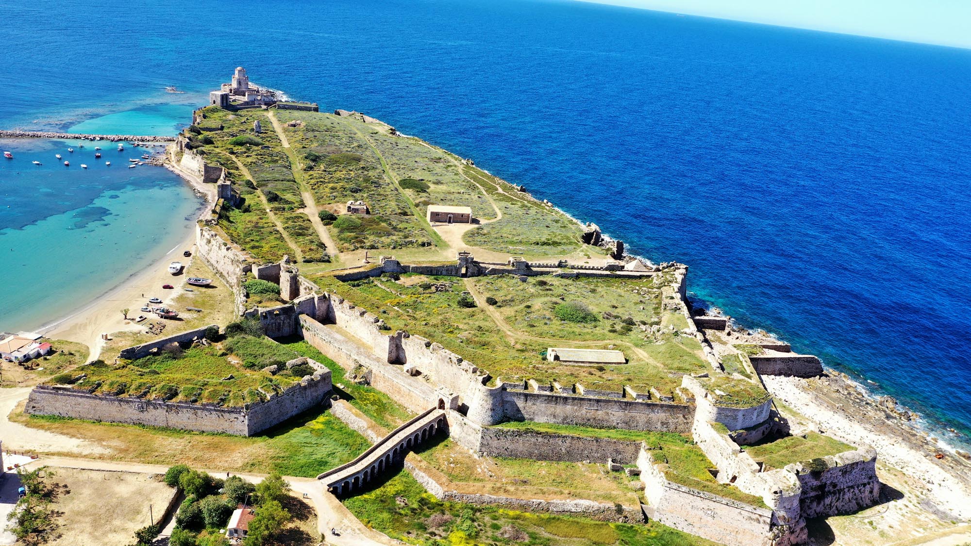
Covering an area of approximately 9.3 hectares, the castle is protected on its northern side by a moat that separates it from the mainland. It is divided by a transverse wall into two unequal sections: the larger southern section, surrounded by a simple sea-facing defensive wall with regularly-spaced towers, enclosed the settlement, while the smaller northern section, located at the only accessible point landward point, was a strongly fortified citadel where the military commander was based.
Venetian naval dominance influenced the general design of the fortifications, with the sea regarded as a natural ally and the primary defensive effort focused on the landward side. As a result, the southern enclosure retains much of the form it acquired between the 13th and 15th centuries.
THE CITADEL (NORTHERN ENCLOSURE)
In the citadel, located in the castle’s northern enclosure, the most critical defensive works were developed between the late 15th century and early 18th centuries in response to the advent of firearms in order to adapt to evolving fortification techniques. The walls were reinforced internally or externally to withstand cannon fire. Medieval battlements and arrow slits were replaced by a straight parapet, cannon embrasures and gun slits, while the rampart-walk was reconfigured into a cannon platform supported by a series of arches.
The landward defences of the castle were complemented by three strong bastions, positioned at the two ends of the moat and the northern corner of the citadel walls. The oldest, the Bembo bastion, was constructed during the first period of Venetian rule in the 15th century. At the eastern end of the moat stands the Loredan bastion, named after Antonio Loredan, Venetian military commander of the Peloponnese. Together with the western bastion, it was completed between 1714 and 1715, based on the designs of engineer Antonio Giancix. A lower rampart wall in front of the main enclosure further reinforced the vulnerable landward side of the citadel between the Bembo and Loredan bastions. Originally constructed in the 15th century, the rampart assumed its current form during the second period of Venetian rule, following the addition of the Loredan bastion.
The wide moat that separates the castle from its northern landward side strengthened its defences. The first major works to create the moat were carried out in the late 15th century and it acquired its current form during the second period of Venetian rule. Crossing the moat is a 14-arched stone bridge, built by the French expeditionary force after 1828 to replace a wooden structure that could be easily destroyed in the event of a siege to cut off access to the castle.
THE GATES
After crossing the bridge over the moat, visitors arrive at the castle’s central gate, constructed in 1714 by the Venetians. The elaborately decorated gate is located at the centre of the bulwark and leads to a protected corridor that runs between the bulwark and the main wall. The corridor ends at the gate to a small fortification enclosure that protected the Land Gate, or Porta di Terra Ferma, that provided access to the castle’s southern enclosure from the landward side.
The castle had three additional gates on the harbour side: the eastern gate, or Porta Stoppa; the harbour gate, or Porta del Mandracchio; and the southern gate (Sea Gate), or Porta di San Marco.
THE INTERIOR
The Land Gate led to the Great Square of Arms (Piazza d’Armi Grande), the focal point of social and economic life. Here stands the so-called Morosini Column, a Roman column of red granite, which likely supported the Lion of Saint Mark. A similar column can be seen on Saint Mark’s Square in Venice. Nearby is the church of the Transfiguration, the only church within the castle to survive intact, likely dating to the second period of Venetian rule (1685–1715).
The northern side of the square was defined by the transverse wall, which separated the city from the northern enclosure/citadel. At the western end of the wall is a small gunpowder storeroom with a characteristic pavilion roof from the second period of Venetian rule (1686–1715). The transverse wall, as well as the gate at the base of its central tower, constituted the only access to the citadel (Iç Kale, an internal fortress for the Ottomans) and dates to the first period of Ottoman rule. There are no buildings preserved within the citadel today, except for a rectangular structure, which is likely a gunpowder storeroom from the second period of Ottoman rule (1715–1828).
Few buildings survive in the southern enclosure, which once housed the densely populated settlement of Methoni. Along the central axis, once lined with shops, taverns and workshops, two complexes of Ottoman baths are preserved. Transverse roads branched off from this main artery, leading eastwards to the harbour. At their ends stood two gates leading to the harbour: Porta Stoppa and Porta del Mandracchio. Near the latter are the low-lying ruins of the large church of Agios Ioannis Theologos, the cathedral of Methoni. Initially the seat of the Orthodox bishop and then, after 1209, of the Catholic bishop of Methoni, the church was converted into a mosque during the Ottoman period. The base of a minaret, still visible in the southwest corner of the ruins, was part of this mosque.
The central thoroughfare led to the second-largest square of the castle, the Square of Arms (Piazza d’Armi), and the imposing southern Sea Gate (Porta di San Marco). Near the Sea Gate, on the southeastern section of the walls, stands the impressive – and restored – tower that once dominated Methoni harbour. The medieval jetty began at the Sea Gate and then turned north, following a course parallel to the eastern wall.
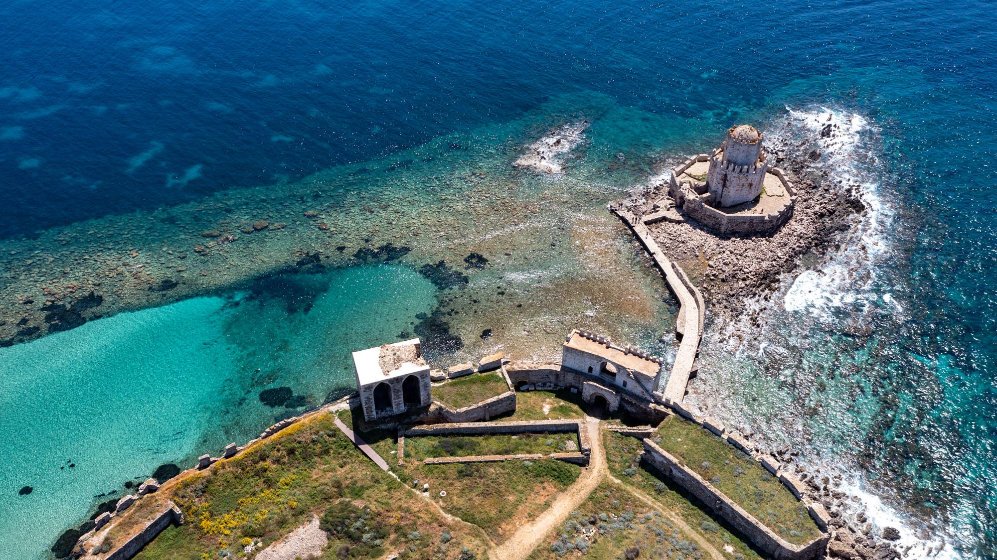
BOURTZI
From the Sea Gate, visitors reach the southernmost tip of the castle, Bourtzi. The octagonal sea fortress on the small skerry dates to the first period of Ottoman rule (1500–1686). Over the centuries, Bourtzi served as the headquarters of a guard, a lighthouse, a prison and a shelter in times of siege. Today it stands as an iconic feature of the castle and a landmark of Methoni.