Kyparissia
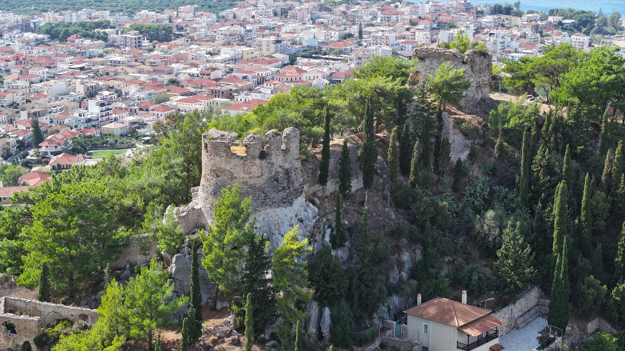
Kyparissia Castle was built northwest of the modern city, on a low hill at the foot of Mount Psychro. Its naturally fortified position, with steep rocky slopes, offered commanding views of the city’s natural harbour, the entire Gulf of Kyparissia and the roads connecting Ilia with Pylia and the Messenian hinterland.
ΑΠΟ ΤΟ ΠΑΡΕΛΘΟΝ ΣΤΟ ΠΑΡΟΝ
In ancient times, the city was known as Kyparissieis and is mentioned in the Homeric epics as part of Nestor’s kingdom, which participated in the Trojan War. An important harbour and commercial centre during the Hellenistic and Roman eras, the ancient city occupied the lowland and coastal areas of the modern one. During the Early Byzantine period, likely between the 6th and 8th centuries, it was renamed Arkadia and developed in the area of the castle and the present-day Upper Town. According to one interpretation, the name change reflects the resettlement of Arcadian inhabitants following the incursion of Slavic tribes into the Peloponnesian hinterland.
After the fall of Constantinople during the Fourth Crusade (1204), Arkadia Castle was one of the few places in the Peloponnese that mounted strong resistance to the Frankish knights. Following a prolonged siege in 1205/6, it became the seat of the barony of the same name, a fief under William of Champlitte, the ruler of the Principality of Achaia. In 1208, it passed as a hereditary fief to his successor, Geoffrey I of Villehardouin. In 1262, the barony passed to Vilain d’Aulnay, while in the middle of the 14th century, it passed to the Le Maure family, which had other fiefdoms in Messenia, and then, in the late 14th century, to Centurione Zaccaria, prince of Achaia.
After 1430, Arkadia, along with the remaining territories of the Principality of Achaia, was granted as a dowry to Thomas Palaiologos, the son-in-law of Centurione Zaccaria, and became part of the Despotate of the Morea until 1460, when the Ottomans abolished it. Under Ottoman rule, Arkadia continued to flourish and was the seat of a kaza (administrative district).
In 1686, the castle was besieged and captured by the Venetians. Before abandoning it, the Ottomans set fire to and blew up its towers. During the brief period of Venetian rule that followed, the castle declined in importance, as its location was now considered vulnerable. Nevertheless, it remained the seat of an administrative district (territorio) and maintained a Venetian garrison. In 1715, along with the rest of the Peloponnese, it was recaptured by the Ottomans, who, in the 18th century, conducted limited repairs to the walls and towers.
In 1770, during the Orlov Revolt, the castle suffered extensive damage. On 27 March 1821, the Ottomans surrendered Arkadia to the Greeks, but in 1825, both the castle and city were destroyed by Ibrahim Pasha’s forces. In 1833, Arkadia was renamed Kyparissia, and its castle permanently lost its military function. A powerful earthquake in 1886 caused significant damage to both the castle and the city.
THE CASTLE
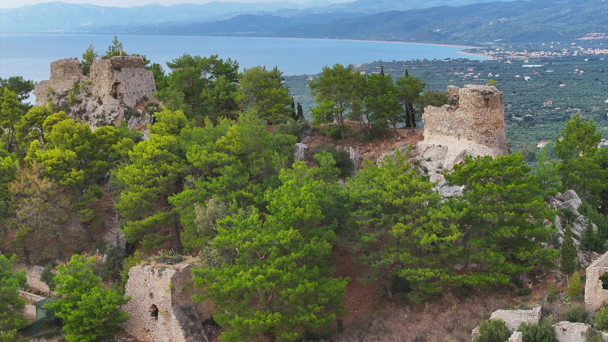
The castle occupies an area of about 6,500 square metres. Its walls form an irregular four-sided plan, adapted to the contours of the terrain, although parts of the northern and southern sides of the fortification have been lost. It complex features two enclosures: an inner (northern) and an outer (southern) one, separated by a transverse wall running along the East-West axis. In several places, particular in the transverse wall and the older parts of the castle, building material from the ancient acropolis of Kyparissia, which stood on the same site, has been reused. The original fortress, constructed before the introduction of firearms, featured vertical walls reinforced by four-sided towers, battlements and a rampart-walk. Over time, and in response to evolving defensive tactics, the castle underwent various reinforcements and additions, none of them systematic.
In the surviving sections of the fortifications, evidence of repairs and alterations is clearly visible, particularly those made after the widespread adoption of firearms. During both the Venetian and Ottoman periods, efforts were made to reorganise the fortress through the addition of bastions, the reinforcement the walls with a batter and creating gun slits.
THE GATES
The castle’s central gate was located on the eastern side of the lower enclosure, near the point where the modern entrance to the archaeological site stands, according to a site plan from the Venetian period. It is incorporated into a four-sided tower, and has been dated to the 15th or the 16th century.
The gate that led to the inner enclosure of the castle has been destroyed, but the same site plan indicates that it too was part of a tower structure.
THE CASTLE INTERIOR: THE TOWERS
Of the castle that was besieged by the Frankish knights of the Fourth Crusade, two elements have been preserved according to scholars: an underground cistern (not open to the public), located in the middle of the northwestern side of the inner enclosure, and the original construction phase of the U-shaped tower/bastion in the northeastern corner of the inner enclosure. This bastion, known as the Tower of Justinian or Small Dapia (“Small bastion”), had as its primary purpose the protection of the particularly vulnerable eastern side of the castle and the gate leading to the settlement. Its conversion into a bastion (i.e., for artillery use) dates to the 15th or 16th century, while its upper level seems to have been further reinforced during the Ottoman period.
At the highest point of the castle, atop a rocky outcrop, stands a fairly well-preserved, strong four-sided tower known as the Central Dapia. Its size, location and design suggest it functioned as the central donjon, or keep, during the Frankish period. Together with the distinctive configuration of the entrance gate to the inner enclosure, which is also located in a tower, these features support the hypothesis that the Franks designed the castle to not only be a refuge for the population during hostile raids but also as the local lord’s residence.
The settlement of Kyparissia began expanding beyond the city walls as early as the Byzantine era, forming a suburb mainly in the area of the present-day Upper Town. In the 17th century, the Ottoman traveller Evliya Çelebi mentions the existence of about 80 houses within the castle. The interior remains unexcavated.
During the 1970s, the castle grounds were planted with trees, and a stone open-air theatre was constructed for events.