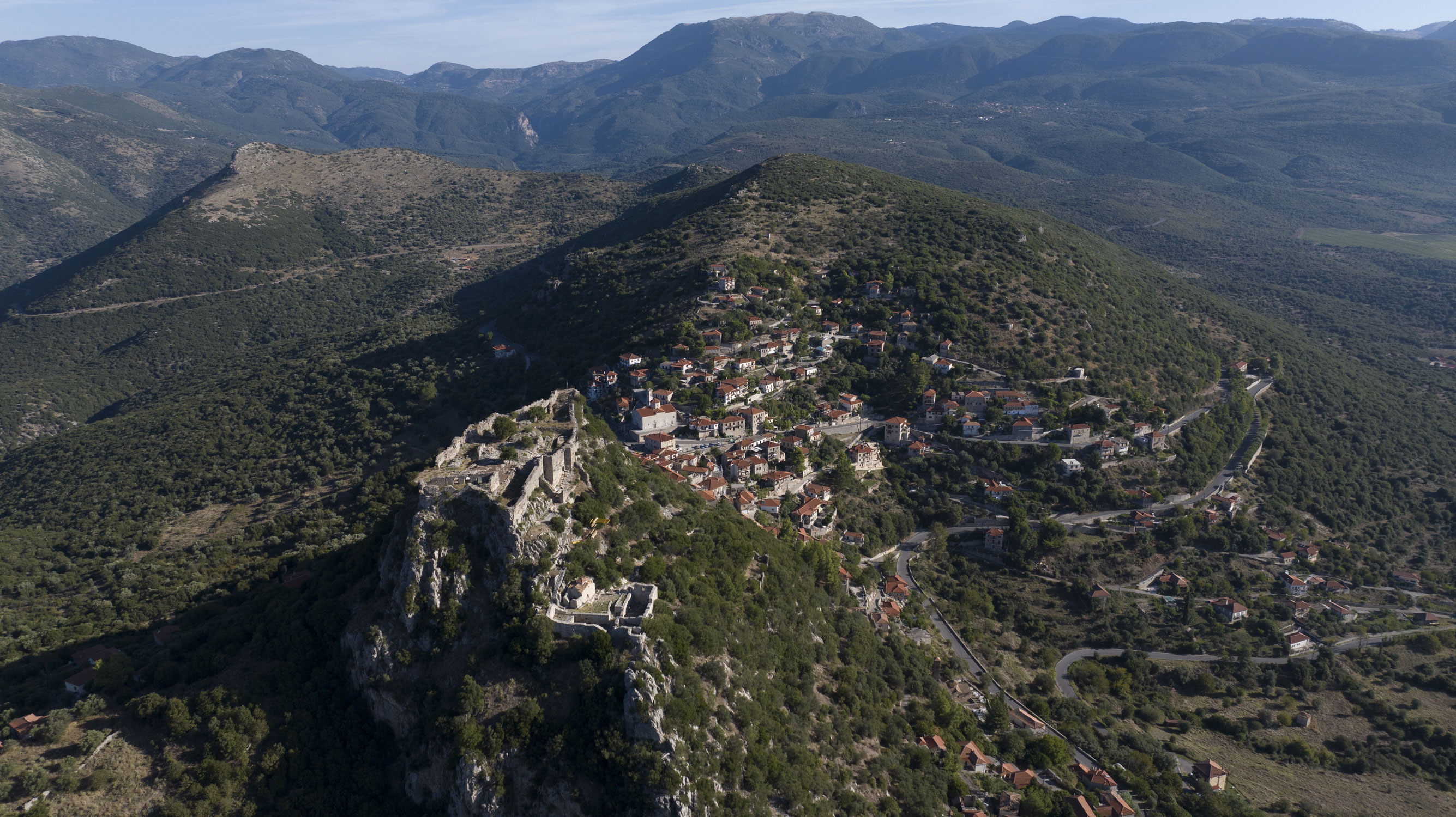
Karytaina
Karytaina Castle was erected in the 13th century in a naturally fortified position, atop a hill on the western side of the steep ravine of the River Alpheios. From this strategic vantage point, it oversaw the wider Megalopoli Plain and the Skorta Pass, controlling the main routes that connected western Arcadia with Ilia and Messenia as well as the Alpheios Valley.
ΑΠΟ ΤΟ ΠΑΡΕΛΘΟΝ ΣΤΟ ΠΑΡΟΝ
In antiquity, the site of the castle likely coincided with the ancient city of Vrenthi, which was abandoned in 370 BCΕ when the Theban general Epaminondas founded Megalopoli, compelling the inhabitants of all surrounding settlements to relocate there. In the following centuries, there are no historical references or written sources concerning the site.
After 1204, following the Frankish conquest of the Peloponnese and the establishment of the Principality of Achaia, the site reemerged in history under the name Karytaina. It was designated the seat of a barony, governed by Hugh of Briel (also referred to as Hugues de Brières or de Bruyères in older literature). His son Geoffrey built the castle in the mid-13th century, transforming it into the main administrative and commercial centre of Gortynia, with a settlement developing around it.
In 1275, Geoffrey died without any offspring. As a result, the barony was divided: one half went to his widow, Isabella de la Roche, and her new husband, Hugh of Brienne, while the other half was granted to William of Villehardouin, prince of Achaia. In 1289, the lands of the barony were ceded to the new rulers of the Principality of Achaia, Isabelle of Villehardouin and her husband, Florent of Hainaut. Then, in 1303, the castle was inherited by Isabelle’s daughter Margaret, following her mother’s will.
In 1320, the castle was captured by Andronikos Palaiologos Asen and came under the control of the Despotate of the Morea. During this period, as evidenced by the Late Byzantine tower houses and numerous churches, the settlement of Karytaina remained an important centre. However, the castle began to decline in significance.
In 1458, Karytaina was conquered by the Ottomans and remained under their rule until 1685, when it was taken over by the Venetians, along with the rest of the Peloponnese. Following the end of the second period of Venetian rule in the Peloponnese in 1715, the Ottomans regained control. During this time, Karytaina flourished as the region’s primary agricultural and commercial hub, with a bustling market primarily for grain. The settlement expanded and its population grew.
The castle played an important role in the Greek Revolution. On 27 March 1821, during the Battle of the Agios Athanasios Pass at Karytaina, the Ottomans took refuge in the castle, repelling a Greek raid. Eventually, the Ottomans set fire to the castle and the settlement of Karytaina before fleeing to Tripoli for greater protection. In 1826, Theodoros Kolokotronis repaired the castle’s fortifications and organised them to serve as a shelter and base for the Greeks during their operations against Ibrahim Pasha, who was leading a military campaign in the Peloponnese.
THE CITADEL
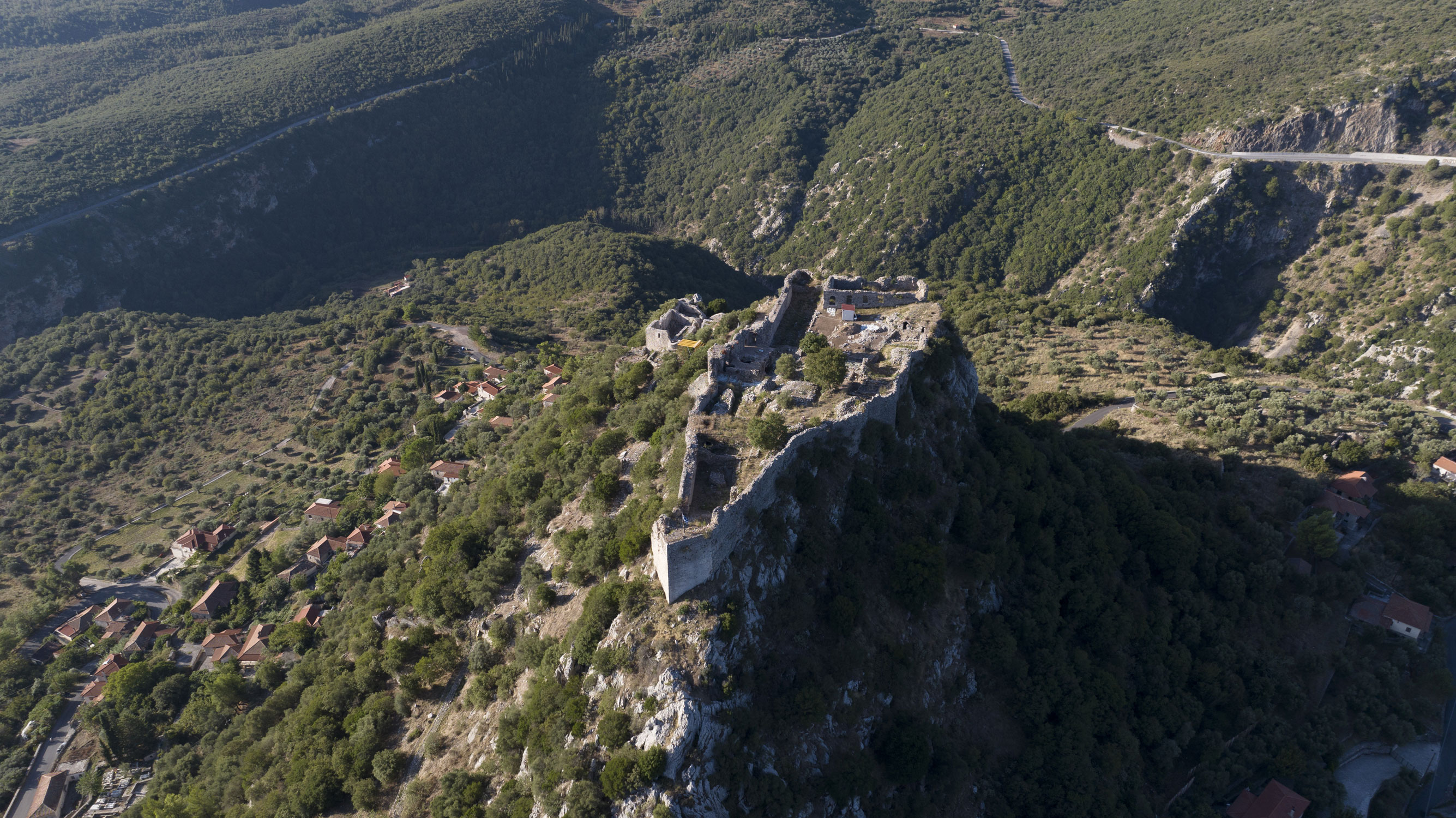
The citadel of Karytaina is built at the top of the hill above the settlement. It displays a structural homogeneity that supports its dating to the mid-13th century, with only limited later interventions that did not significantly alter its original medieval form.
The citadel has an elongated, almost triangular, layout, with strong walls that follow the contours of the terrain, enhancing the site’s natural fortification. It measures more than 110 m in length, being wider on its southern side and much narrower in the north. Its defences are reinforced by solid towers positioned at the corners and a semicircular tower in the centre of the western side.
The entrance to the citadel is located on the southeastern side of the walls. An arched gate, flanked by solid towers, leads through a vaulted passageway into the inner courtyard of the citadel. Above the gate, a rectangular opening likely once displayed a coat of arms. The gate was also protected by a rectangular outer bulwark, which enclosed a small courtyard and was accessed through an arched gate to the south.
THE INTERIOR
Around the citadel walls and the inner courtyard, mainly two-storey wings were erected, including the living quarters of the baron’s family, the garrison and auxiliary spaces, such as vaulted cisterns and large storerooms. The official reception hall, built over a large underground cistern in the southern wing, featured double-light windows, with carved frames, and a fireplace.
In the centre of the courtyard, the foundations of the large central donjon, or keep, are preserved. It once dominated the castle, serving as the last refuge and final point of defence in the event of a siege.
THE KOLOKOTRONIS RESIDENCE COMPLEX
This building complex is strategically located on a flat area below the citadel, overlooking the entrance from the direction of Megalopoli. It was L-shaped with two storeys, including auxiliary rooms on the ground floor and living spaces on the upper floor. The structure’s initial construction dates back to the medieval era, though later additions include small circular corner towers designed to enhance its fortification capabilities.
Theodoros Kolokotronis is said to have settled in the complex in 1826, during the military campaign against Ibrahim in the Peloponnese, and to have hosted, in the summer of 1829, members of the French scientific commission of the Morea during their visit to the area.
THE CHURCH OF PANAGIA
Inside the fortified medieval settlement, next to the Kolokotronis residence, stands the church of Panagia, which belongs to the two-columned cross-in-square type. It was built in a subsequent phase to the establishment of the castle by the Franks, as indicated by two elaborate Middle Byzantine capitals that were reused in its interior. During the Ottoman period, extensive repairs were carried out in the vaults, the sanctuary and the two doors of the church.
MATZOURANOGIANNIS TOWER
Outside the walls of the castle, to the north and adjacent to the path leading to it, stands a rectangular structure known as the Matzouranogiannis Tower. The tower was constructed during the period when the Byzantines recaptured Karytaina from the Franks. It was at least two-storeys high and included a vaulted cistern on the ground floor and a living space on the upper floor. The entrance to the tower was on the upper floor and is surrounded by rich decorative brickwork. A built staircase led either to a second – now lost – floor or directly to the roof terrace, which, in any case, had battlements.