Glarentza
Glarentza, known to the Franks as Clarence or Clarentia, was founded on the northwestern end of the westernmost peninsula of the Peloponnese, on the site of ancient Kyllini. It served as the port of Andravida, the capital of the Frankish Principality of Achaia. Alongside nearby Chlemoutsi Castle, it constituted the principal defensive stronghold of the region. Its significance was crucial, as it facilitated the movement of goods and troops to and from the West. Despite its relatively brief existence of less than two centuries, it rose to become one of the most important cities of medieval Greece.
ΑΠΟ ΤΟ ΠΑΡΕΛΘΟΝ ΣΤΟ ΠΑΡΟΝ
Glarentza was established shortly after the mid-13th century by Prince William II of Villehardouin (r. 1246–1278) and stands out as one of the few cases where the Franks chose to build a city from scratch instead of using a pre-existing Byzantine settlement. From its inception, Glarentza functioned as the main commercial and military harbour of the principality, rapidly developing into a major urban and economic centre with an international reach. Over time, it gained an administrative significance equal to that of Andravida. It had its own system of weights and measures, and in 1267, with the permission of King Louis IX of France, a mint was established in the city that issued deniers tournois. Following that year, when the principality became a vassal of the Angevin Kingdom of Naples, Glarentza flourished further. Venetian and other Italian merchants dominated the city, contributing significantly to its economic development.
The city suffered its first major destruction around 1380, when it was attacked by the Navarrese company. By 1391, a census recorded only 300 houses in Glarentza, inhabited primarily by Italians and some Greeks. In 1407, it was plundered by Leonardo II Tocco, who held it until 1414, when it was restored to the principality under Prince Centurione II Zaccaria. In 1417/18, the city fell to the Italian adventurer Oliverio Franco and in 1421/22, it was sold to Carlo I Tocco, count of Kefalonia and despot of Epirus.
In 1427, Byzantine Emperor John VIII Palaiologos laid siege to Glarentza. The following year, Carlo I Tocco granted it as a dowry to John’s brother Constantine Palaiologos, despot of Morea at the time, upon his marriage to his niece. In 1430, it was captured by Catalan mercenaries, who, in the same year, sold it to Constantine. The latter decided to tear down its walls to prevent a new occupation. In 1432, his brother Thomas Palaiologos designated it as the capital of a second despotate in the Peloponnese. In 1446, Sultan Murad II inflected extensive damage on the city, which in 1460 surrendered to the Ottomans. Thereafter, the city was abandoned, with later travellers mentioning only its ruins.
In 1922, Glarentza was declared an archaeological site. However, the land was allocated to Asia Minor refugees for cultivation, leading to extensive alterations through systematic tillage. During World War II, it suffered another decisive blow, as the occupying troops blew up almost every ruin that still stood above ground.
Today, Glarentza survives in a heavily ruinous state, but recent archaeological research has yielded important information about the form of this once glorious Frankish city.
THE CASTLE
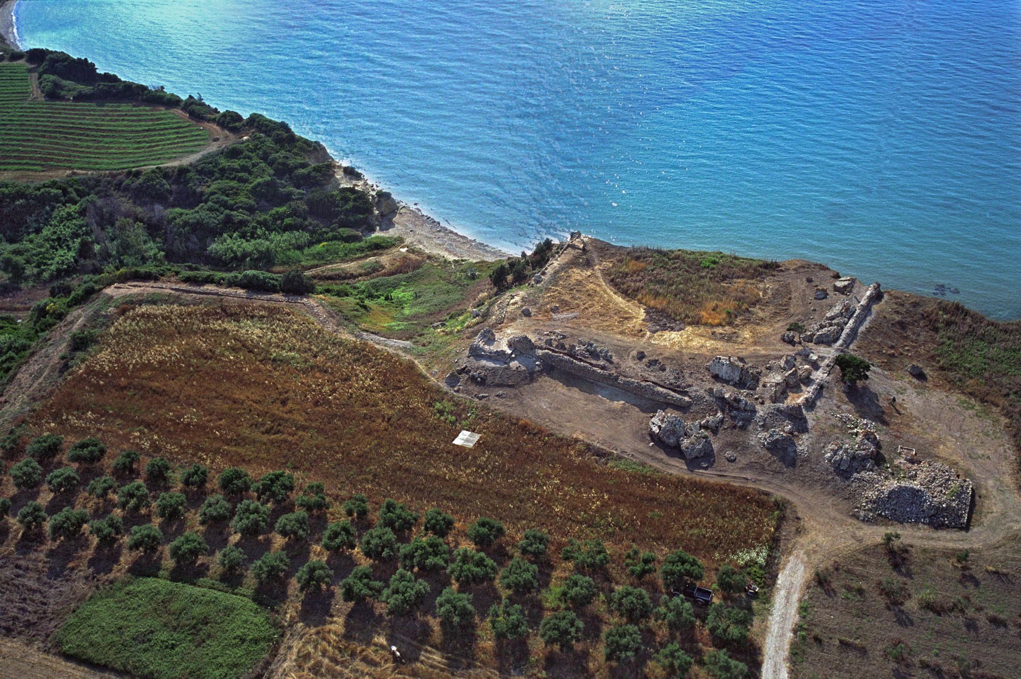
The fortified city developed atop a slightly elevated area of 15.75 hectares. Its southern and eastern sides were protected by walls that followed the contours of the terrain and were reinforced by a deep moat. At key points, such as corners and gates, rectangular towers were constructed, traces of which were uncovered during recent excavations. The northern and western sides, bordered by the sea, were unwalled. An internal cross-wall on the northern side separated the city from the harbour and the emporion, that is, the area of commercial activity.
At the most fortified point of the city, above the steep western coast that offers a natural defence, the ruins of a small rectangular shaped fortress and four-sided towers in the corners are located. Archaeological data, along with an epigraphic inscription of 1441–1442, date the inner enceinte establishment to when the city belonged to the Palaiologos family. However, earlier architectural remains, as well as a stone slab bearing the Villehardouin coat of arms, indicate that the residence of the Frankish prince in the city was likely located here.
The precise layout of the residential structures of Glarentza remains unknown, as its interior has not been extensively researched. However, as it was built from scratch, it is believed to have been carefully designed, as indicated by the location and orientation of the few surviving buildings. Though relatively small, the fortified city likely extended beyond its walls, spreading along the two main roads leading to Andravida and Chlemoutsi.
THE GATES
The outer enclosure contained three gates, now destroyed. The first, known as the Sea Gate, as mentioned in the Chronicle of the Tocco, was located in the cross-wall and led to the emporion and harbour. The second, to the east, led to the road towards Andravida. It was reinforced with a tower and fronted by a stone arched bridge spanning the moat; part of the paved road survives. The third, in the southeast, faced Chlemoutsi Castle and was also tower-shaped.
Access to the fortress’ inner enclosure was through an elevated gate with a Gothic frame, located in the southeastern tower.
THE INTERIOR
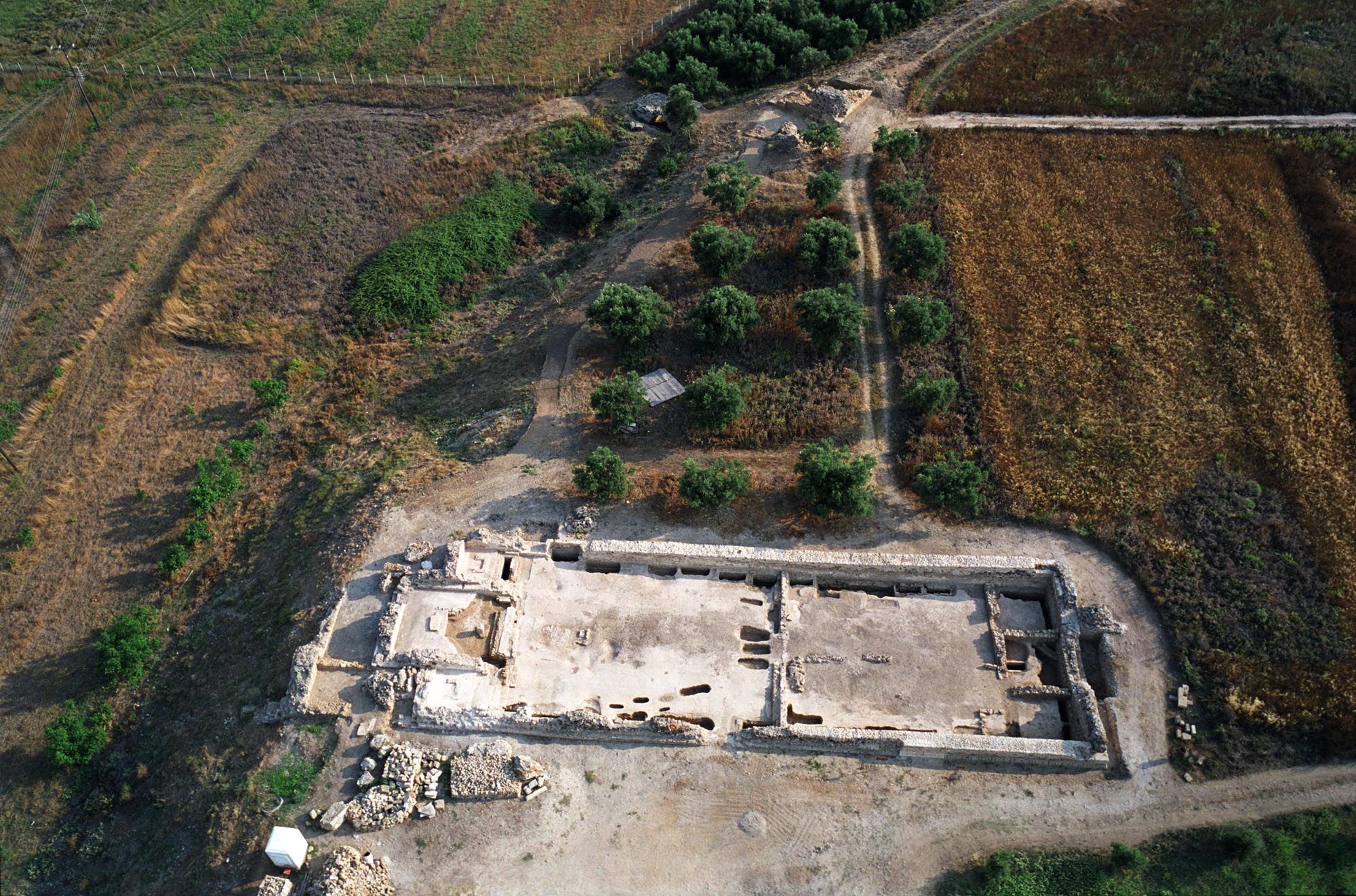
Today, few ruins are visible within the city, apart from the small fortress to the west. On the eastern side, near the entrance to the present-day archaeological site, lie the excavated remains of a large church, identified as Glarentza Cathedral, dedicated to Saint Francis. The Frankish rulers held their assemblies at this church, which was also a burial place for nobles of the principality.
The church, built around the mid-13th century, was an impressive aisleless timber-roofed Gothic basilica featuring a rectangular sanctuary and side chapels covered with groin vaults. Its walls were covered with wall paintings. Excavations have revealed dozens of burials within the church, along with built graves along the long walls of the church, some with pseudo-sarcophagi and arcosolia.
Finally, near the cross-wall that separated the borgo from the emporion and the harbour, the remains of two more buildings are preserved: a two-storey L-shaped structure featuring a monumental staircase on its southern side, which remains unidentified, and a structure with three halls, which was probably an Ottoman bath.
THE HARBOUR
The harbour, in continuous use from antiquity through the Middle Ages, was located in Arsanas, a swampy area on the northern side of the city. According to both archaeological evidence and the Chronicle of the Tocco, the medieval harbour was fortified by a pair of towers that were part of the city walls and was capable of accommodating large vessels. The harbour has been filled in. However, sections of the piers and one ancient tower have survived, as have a submerged part of the jetty and remains of the eastern tower of the medieval harbour.