Geraki
Geraki Castle was built on a southwestern foothill of Mount Pardon that is now known as Palaiokastro. Its strategic location provided commanding views over the main roads that connected central Laconia with Kynouria, the eastern Peloponnese and the Maleas Peninsula, while overseeing the extensive Geraki Plain that extends to the shores of the Laconian Gulf.
ΑΠΟ ΤΟ ΠΑΡΕΛΘΟΝ ΣΤΟ ΠΑΡΟΝ
The earliest evidence of habitation in the wider area comes from the prehistoric, walled acropolis atop a nearby hill now known as Dontakia, on whose slopes the modern village of Geraki is situated. Pottery sherds and obsidian tools from Melos, dating to the late Neolithic period, have been discovered there. This hill was the site of Geronthrai, an important Laconian state that flourished from the Bronze Age to the Byzantine period. The identification of the modern settlement with the ancient city is supported by the account of Pausanias, who toured Greece in the 2nd century.
The renaming of the state to Geraki likely dates to the final phase of the Middle Byzantine period, sometime between the 11th and, at the latest, 12th century, when feudal tendencies began to emerge in the Byzantine Empire. The name probably derives from a wealthy local landowner active in the area at the time.
Byzantine Geraki must have developed rapidly from the 10th century onwards, as evidenced by its flourishing after the 12th century. This prosperity is reflected in the high concentration of Late Byzantine churches within the settlement and castle, notable for their elegant architecture and high-quality murals.
A topographical study of the monuments in this area concluded that the settlement in the plain remained inhabited during the late Middle Byzantine era and the early phase of the Late Byzantine period. Concurrently, building activity began in the 13th century, marked by the construction of the castle on Palaiokastro Hill in the mid-13th century. Gradually, the old city was abandoned as habitation shifted to and around the medieval castle.
According to the Chronicle of the Morea, the castle was founded by either the Frankish baron Guy de Nivelet or his son, Jean, who was granted Geraki along with six fiefdoms, thereby becoming one of the 12 Frankish baronies of the Peloponnese. In 1259, William II of Villehardouin, prince of Achaia, was defeated and captured by the Byzantines at the Battle of Pelagonia. He remained their prisoner until 1262, when the Franks surrendered the castles of Mistras, Monemvasia, Megali Maini and Geraki in exchange for his release.
During the Byzantine period, the castle and settlement flourished, largely due to their strategic location on the road connecting Mistras and Monemvasia, the two most important cities of the Despotate of the Morea. In 1460, the area, along with the rest of the Peloponnese, was conquered by the Ottomans, under whom it remained, with brief interruptions, until the Greek Revolution of 1821. The Ottoman rule of the Peloponnese from the 15th to the 19th century was interrupted only during the First Venetian-Turkish War (1463–1479) when the Venetians temporarily occupied some forts and again during the second period of Venetian rule of the Peloponnese (1685–1715).
The castle was gradually abandoned from the mid-15th century onwards, and by around 1700 the settlement had relocated to its present location. It was only in September 1825, after the burning of the village by Ibrahim Pasha’s troops, that the inhabitants of Geraki temporarily sought refuge in the castle again in their attempt to defend and protect themselves.
THE CASTLE
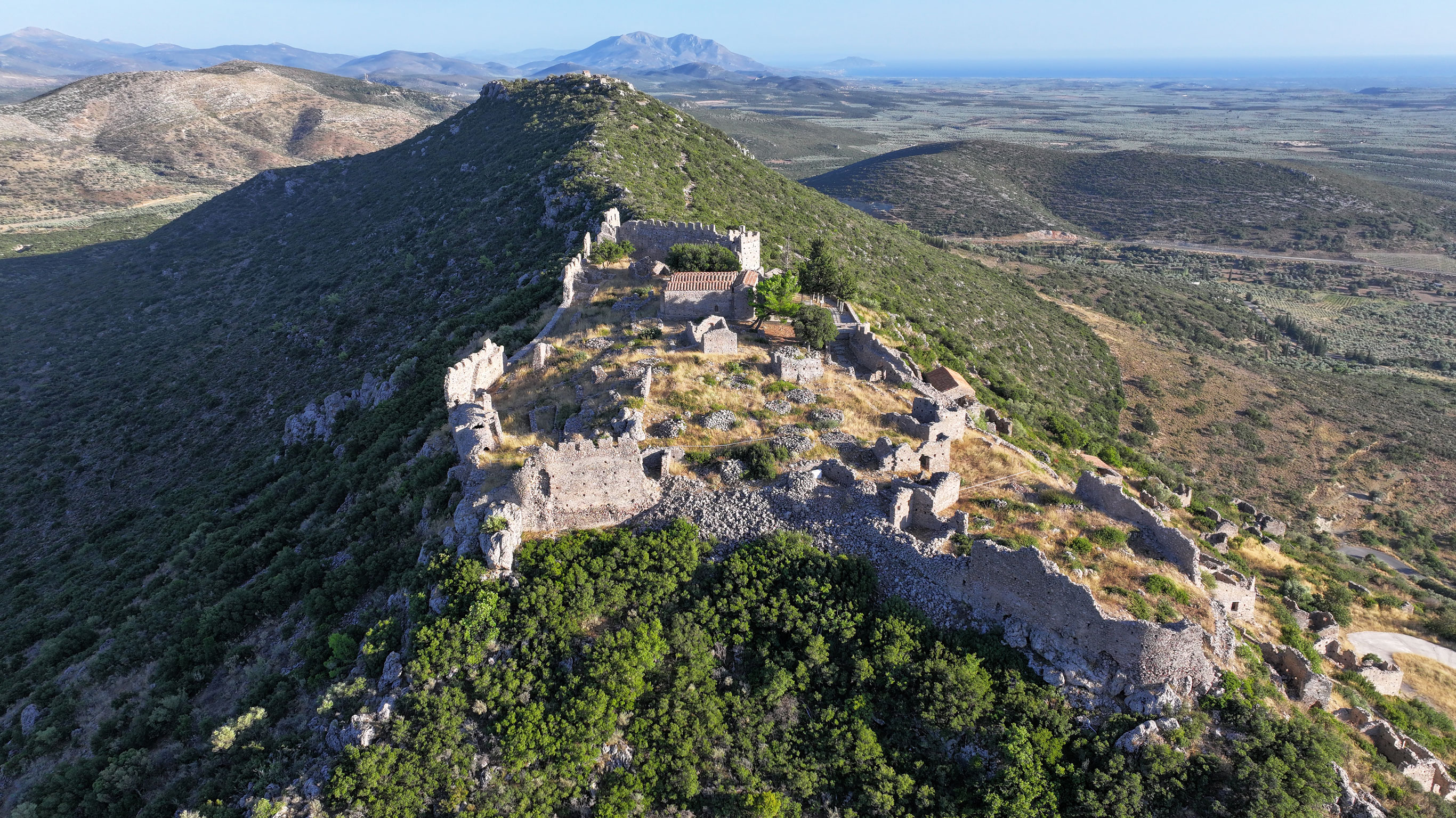
Geraki Castle occupies the highest northern peak of Palaiokastro Hill. Its walls follow the contours of the natural terrain, forming an irregular, multifaceted layout. The castle measures approximately 125 m in length (north to south) and about 65 m in width, enclosing an area of around 0.8 hectares.
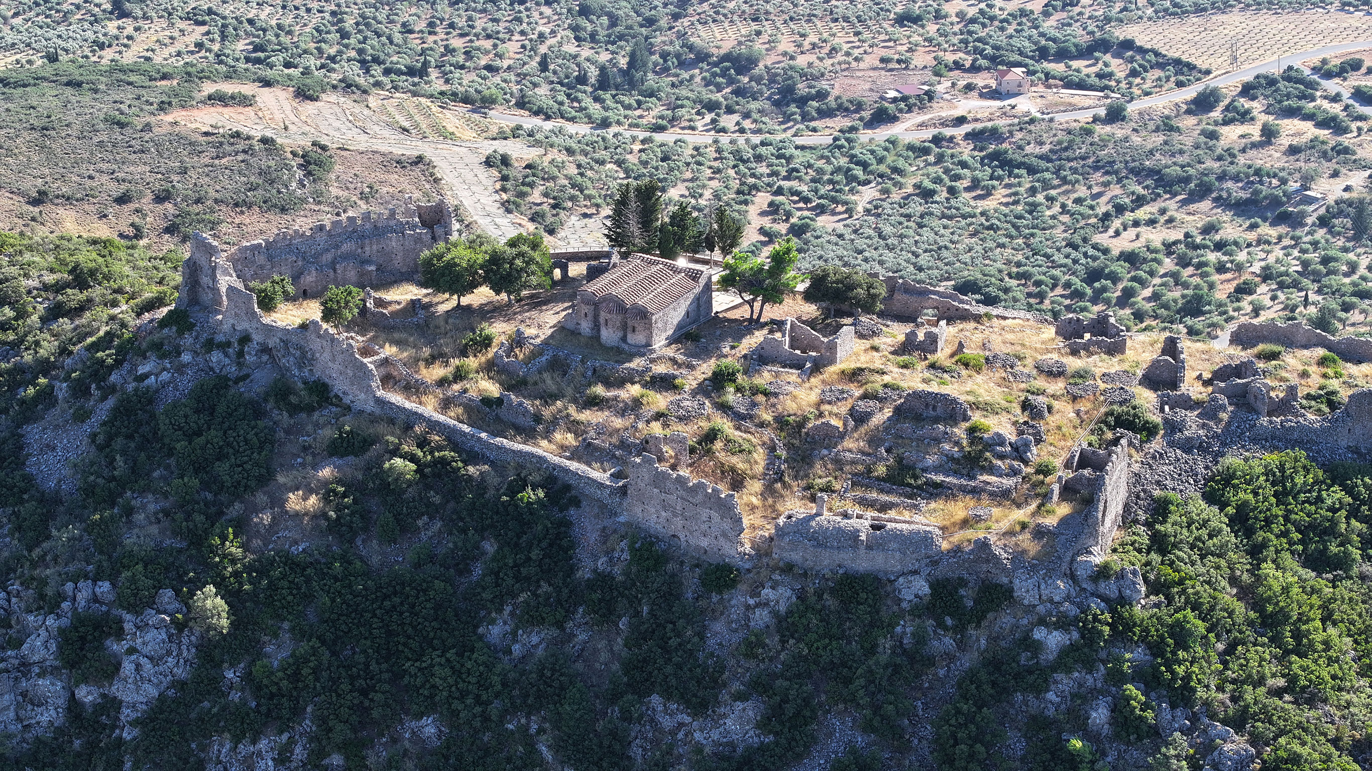
Its central entrance was located roughly at the centre of the western wall, where the main road of the settlement ends. Above the arched gate of the wall is an empty blind arch, in which the coats of arms of the family of the castle’s Frankish founder may have been displayed. Of particular interest is the decorative brickwork in a cross-hatching pattern, which extends in a band on either side of the central gate, above the base of its arched lintel, a characteristic feature of Late Byzantine architecture.
The castle wall was reinforced with towers and battlements. Its most vulnerable southern side was strengthened with the addition of two large, square towers, likely following its recapture by the Byzantines.
Although the exact date of the castle’s construction remains uncertain, it has been argued that was built in the mid-13th century. The monument also underwent a repair phase following the Byzantine retaking of the fortress in 1262.
A substantial portion of the castle’s fortification, including towers, battlements, embrasures, as well as the staircase leading to the rampart-walk, has survived. Within the enclosure, architectural remains of various buildings, some freestanding, others organised into complexes, are still visible. Among them are two large, multi-roomed structures believed to have served as the residence of the Frankish lord. Also located within the castle is the church of Agios Georgios, a three-aisled basilica with a narthex dating to the 13th century, which probably functioned as the main church of the fortified settlement. It preserves almost all its murals from the late 13th and 14th centuries, along with an elaborately carved frame (proskynetarion) surrounding the depiction of Saint George on horseback.
The castle also contains two cisterns.
THE SETTLEMENT OF GERAKI CASTLE
Residential activity within and around the castle continued throughout the Late Byzantine period. Today, the ruins of houses and churches dating from the 13th to the 15th century remain scattered across the site, serving as enduring witnesses to a period of great prosperity of the Byzantine city.
The remains of the settlement can be traced across the two peaks of Palaiokastro Hill. The buildings of the main settlement extended across the northern peak and the western slope beneath the castle. This settlement occupied a trapezoidal slope, the northern side of which was naturally fortified by the rock, forming a defensive wall, while its southern side opened onto the slope.
The settlement developed with varying density and can be divided into three main building units or neighbourhoods. Traces of the settlement’s road network are evident in cut corners, house entrances, carvings in the bedrock, built steps, terraces and retaining walls. At least three roads and a complete network of paths have been identified.
An open space exists in the lower zone of the settlement, around the perimeter of which stand two notable churches: the transverse-vaulted Agia Paraskevi church, later expanded with side aisles (first half of the 15th c.), and the aisleless barrel-vaulted church of Agia Aikaterini, also later enlarged with a side aisle and with 14th-century murals.
From this open area began the main roads and paths of the settlement. The presence of a large public water cistern in this area has led to the hypothesis that the open area functioned as a communal space, hosting social gatherings and commercial activity directly related to the entrance to the settlement.
A type of perimeter fortification for the protection of the settlement has also been identified, a feature common to almost all mountainous settlements beneath castles of the Late Byzantine period, such as those of Mistras, Monemvasia and Mouchli (Arcadia).
In this core residential area are also located the aisleless church of Zoodochos Pigi (first half of the 15th c.), the semi-ruinous double-aisled, arched church of Agios Dimitrios (with murals from the 13th–14th c.), an anonymous aisleless church that the local inhabitants refer to as the “lean-to roofed church”, due to its present-day lean-to roof, and two more nameless chapels.
The most important secular structure within this residential core is a complex of four two-storey buildings situated north of Agia Paraskevi and west of Agios Dimitrios, commonly referred to by locals as the Nivelet Residence. As the residence of the Frankish ruler would have been located inside the castle, this building may have belonged to a powerful Frankish noble.
Although the remains of private buildings are limited, it is evident that the castle formed the nucleus of the settlement and that no formal urban planning was implemented. However, a network of paths was constructed to serve the houses and churches, which were built on a sloping terrain. The absence of a planned urban layout, the settlement’s dependence on a castle that functioned as a military and administrative centre and the integration of the buildings into the natural incline of the landscape also characterise Mistras and Mouchli.
The houses of Geraki, like the castle itself, are constructed using rubble masonry with the insertion of chinking stones, a technique also observed in the contemporary structures of Mistras. Typically one or two storeys high, these buildings often feature entrances on the upper floor and minimal external openings for defensive reasons. The ground floor served as a storage area, while the upper floor was used as the living space. Excavation evidence from several buildings indicates that the ground floors were used as workshops. Notably, Building 19, a two-storey structure, has been identified as a weaving workshop based on archaeological findings.
Finally, of particular interest is the method of rainwater collection in the houses of Geraki, where water from the roofs was channelled into underground cisterns, which were located in natural cavities in the bedrock and were coated with hydraulic mortar to ensure waterproofing.
At the southern summit of the hill are preserved the remains of a smaller, more sparsely built residential core. Among the surviving structures today are several ruined buildings, only three of which are preserved to a significant height, and two churches, the transverse-vaulted church of Taxiarches (first half of the 15th c.) and the transverse-vaulted church of Theophania (with murals dating to the 13th c.). This “district” is connected to the central part of the settlement on the northern peak by a path approximately 700 m in length. Approximately midway along this route stands the aisleless church of Prophitis Ilias (first half of the 15th c.). These churches – Taxiarches, Theophania and Prophitis Ilias – are today referred by local inhabitants as the Pera Ekklisies (“Outer Churches”).
In addition to the mural decoration of the church of Agios Georgios and the surviving fragments of mural in the other churches of the settlement, particular interest lies in the wall paintings preserved in four churches of the medieval settlement: Zoodochos Pigi and Agia Paraskevi in the main settlement, and Taxiarches and Prophitis Ilias in Pera Ekklisies, decorated in the first half of the 15th century by a remarkable painting workshop of the late Palaiologan period.